Current Littourati Map

Neil Gaiman's
American Gods

Click on Image for Current Map

Littourari Cartography
  • On the Road
    On the Road
    by Jack Kerouac
  • Blue Highways: A Journey into America
    Blue Highways: A Journey into America
    by William Least Heat-Moon

Search Littourati
Enjoy Littourati? Recommend it!


Littourati is powered by
Powered by Squarespace


Get a hit of these blue crystal bath salts, created by Albuquerque's Great Face and Body, based on the smash TV series Breaking Bad.  Or learn about other Bathing Bad products.  You'll feel so dirty while you get so clean.  Guaranteed to help you get high...on life.

Go here to get Bathing Bad bath products!

Entries in road trip (321)

Saturday
Jun022012

Blue Highways: Alder Creek, New York

Unfolding the Map

We are now climbing into the Adirondacks with William Least Heat-Moon (LHM), Ghost Dancing straining, and we will again reflect on mountains, their majesty, their age, their wisdom, and our admiration of them.  At least I will.  To see where Alder Creek is located, start climbing toward the map.

Book Quote

"I went up into the Adirondacks at a point where they form a virtual wall, and Ghost Dancing labored making the ascent.  No sun in the forest and twelve degrees cooler.  The ancient Adirondack Mountains are much older than the old Appalachians they merge with; consequently, they tend toward roundness with few sharp outcroppings.  Adirondack ('bark eaters') was a contemptuous epithet Mohawks gave to some degenerated tribe so poor it had to eat trees.

"I bought gas in Alder Creek and asked the pumpman what winter was like in the mountains. 'This,' he said and held up the stump of a little finger.  'Frostbite.  Snowfall of a hundred forty-two inches last year, forty-five below, wind chill seventy below. That's what we call winter.'"

Blue Highways: Part 8, Chapter 6


Junction near Alder Creek, New York. Photo by Rick Ehrenberg and posted at ViewPhotos.org. Click on photo to go to host page.

Alder Creek, New York

Never having been to the Adirondacks - I've only really skirted them as I drove through New York - I can't comment on their beauty or the effects of their great age upon them.  But I love mountains, both young and old, and for different reasons.  I grew up in the California Coast Ranges, which are relatively young mountains, about 3-4 million years old, that range near the coast of Northern California.  The immense forces that raised these mountains are tied in with the plate tectonics of the west coast of North America, and where near my hometown the Mendocino Triple Junction of the North American, Pacific, and Gorda, as well as the meeting place for the San Andreas and Mendocino faults with the Cascadia subduction zone.  In other words, it is a cauldron of plate tectonics and this cauldron has created forces which has heaved up the mountains in which I played and explored when I was young.

I'm trying to think of what might be the oldest mountains that I've visited?  The Appalachians would certainly qualify.  The forces that built the mountains may have begun as early as a billion years ago, though 540 million years ago is a good midpoint to think about in terms of when they began to take their present shape.  However, one person disputes this, writing that they are really very young mountains.  I am in no position to agree or disagree.  However, on the gut feeling side which is totally unscientific, they seem to be old mountains to me.  Though my visit in them reminded me of home, I still felt that they were different in some way, that if they could talk they would be older, wiser, and full of stories that my young coastal mountains could not know.  Another mountain range, the Blue Ridge Mountains, which I drove along for a while, might be about 400 million years old, which would put them a close second.  These old ranges, with their wooded sides, eroded and gentle slopes, are beautiful and home to a history as varied as the people who have trod, hunted, fished and settled on and in them over time.

The Sierra Nevada, another mountain range with which I'm quite familiar, is a mystery to geologists.  There is a camp that claims that they are relatively old, at 40-80 million years old, or almost an infant, at 3 million years old.  I have always thought of them as young mountains, given that they are so stark and craggy, and perception is everything, I guess.  If you look at a person and think that he or she is young, then for all intents and purposes he or she is until the truth is revealed.

The mountain ranges I currently live near, the Sandias and Manzanos, formed about 10 million years ago, the result of the geological forces associated with one of only two continental rift valleys (the Rio Grande Valley - the other is the Great Rift Valley in Africa).  These certainly make them older than the mountains I grew up in, but younger than most of the other mountains I've frequented.

From what I've read, the Adirondacks are much more complex than LHM imagined.  The Adirondacks can be considered ancient, because they are made of ancient rock that was created and buried 30 miles below the earth's surface.  The age of the rocks are anywhere from 1-2 billion years old.  However, the forces that pushed them to the surface and created the Adirondacks is much more recent.  Sometime around 65 million years ago, the land began to rise, pushing those ancient rocks to the surface.  Then erosion began to form the Adirondacks, leading to the mountains that are familiar to those in that part of the country.

I love mountains, whether they are old or young.  When camping out at my property in the Irmulco Valley, some of my most serene and sublime moments have come while traversing a mountain ridge and hearing the wind through the evergreens overhead.  The vistas that can be seen from a mountaintop are those that can stay with one forever.  While driving along the Blue Ridge Mountains, just looking down over the fields far below almost gave me a feeling of flying, even though my car wheels were held fast to the road.

On the other hand, just looking at a craggy mountain vista, such as when one approaches the Rockies or the Sierra Nevadas, gives one such a perspective.  When I've gazed upon these mountains looming in the distance, there are times that I feel small and appreciative of the wonders that God or gods, Nature, the Universe, or whatever one might believe in, put on this earth.  I sometimes wonder if they were put here for me to admire, or whether it doesn't matter.

I think the gift of a mountain is simply that we ARE here to admire it, to let the mountain free our minds to imagine what it would be like at the top, or if we are at the top, to wonder what might be going on to those unseen down below.  I believe that whether the mountains speak to us from the ages when the earth was young, or in the blink of a couple of million years, they speak truth.  Their truth is that they are there, fixed and permanent, as marker and metaphor in our lives.

Musical Interlude

Mountains put me in a reflective mood, and so does Stevie Nicks' song Landslide, which uses the mountain both as a metaphor for a change in life, and the potential pitfalls that can occur.  Right now my wife and I are in a place of change, and she has a mountain to climb and is concerned about the potential landslides.

If you want to know more about Alder Creek

I'm sorry, Littourati, but there just isn't anything of substance on Alder Creek.  It might be that the community is just too small.  Here's some links on the Adirondacks in general.

Andirondack Region of Northern New York
The Adirondacks
Wikipedia: Adirondack Mountains

Next up: Forest House Lodge, New York

Wednesday
May302012

Blue Highways: Rome, New York

Unfolding the Map

I remember it was always an adventure to go downtown, even in my own little small town where I grew up.  Many downtowns today, after struggling, are finding themselves again thanks to new initiatives.  William Least Heat-Moon (LHM) wasn't that impressed by Rome, New York's downtown, but perhaps it too has found rejuvenation in new ideas and initiatives.  To see where this downtown is located, forget all your troubles and cares at the map.

Book Quote

"On down the highway to Rome, New York.  From its appearance, it could have been London in 1946: the central section gutted but for a few old brownstone churches, a new shopping mall with triple-tier parking lot, and the National Park Service reconstruction of eighteenth-century Fort Stanwix covering several blocks on the east side.  While the palisaded fort had been elaborately rebuilt, it did not turn Rome back into a city, and while ribbon development along the highways gave an economic life, it didn't give Rome a center.  The place looked as if it had died of heart rot - from the inside out."

Blue Highways: Part 8, Chapter 6

City Hall in Rome, New York. Photo by Doug Kerr and hosted at Wikimedia Commons. Click on photo to go to host page.

Rome, New York

This is not a new theme for me, but I will touch on it again.  I want to start this post by saying that 30 years is a long time.  LHM penned what he saw in the early 1980s.  As I write in 2012, for all I know Rome does not resemble anymore the place that LHM described, or perhaps it might still be as LHM wrote.  The issue of downtowns, and stagnation, seems to be perpetual.

Downtowns in towns and small to medium-sized cities have it very difficult in this day and age.  For many of them, development happens, as LHM describes, in ribbons along the highways in and out of town as the downtown, unless it has a comprehensive development plan in place, withers.  Another problem has been the growth of strip malls and big box stores, such as Wal Mart, Costco and others that set up on the outskirts of towns and cities, drawing people away from downtowns and local businesses with their slogans that always have to do with low prices and big savings.  A third problem is the towns and cities themselves, when they let owners keep unused buildings vacant and boarded and contribute to the perception that the downtown is wilted.  A fourth problem is the closure of traditional industries that cannot compete in a world economy, or the relocation of those industries to cheaper markets overseas.

If you drive through the United States, you'll see many towns and cities like this, from the backroads and blue highways of the rural states to the urban blight of Detroit.  And everywhere, the mantra is the same.  "We have to bring new business downtown."  "We have to make downtown a place where people want to be."

Unfortunately, in my opinion, most places are in a Catch-22.  We want the private sector to step in, renovate the empty buildings and establish businesses.  Capitalism doesn't always oblige us, however.  If a place is a losing bet - if you think that you want to establish a small hardware store in the downtown, then you better hope that there isn't a Lowe's somewhere nearby because you'll be out of business soon.  If you want to open a restaurant featuring locally made products, then you better have a plan to draw customers from the Applebees, Fuddruckers, and Red Lobster out by the freeway.  In fact, for a while, it was the biggest companies, usually chains, that always won, save for a few businesses that were able to keep customer loyalty over the years.

Even in my city, Albuquerque, with a population of 450,000, the downtown is not someplace where I want to spend a lot of time, especially in the evening.  It is made up mostly of bars and, I kid you not, a strip club in the main part of the downtown.  Sure, there are a couple of nice restaurants, and a beautiful theater that is now being utilized more often.  There's also an amazingly innovative art gallery and interesting shops.  However, it seems that the market right now is for young people to cruise up and down Central Avenue and go to the bars, and from 2-3 in the morning the downtown becomes a place that is very annoying and sometimes dangerous.  But it seems that no matter how hard it tries, Albuquerque just can't come up with a comprehensive economic development plan that will make downtown a place that appeals to everyone at all times, not just the cruisers and wanna-be gangbangers who clog the streets in the evenings.

However, happily there are signs of hope.  One has been the "buy local" movement.  One of my wife's favorite things to do, wherever we happen live or visit, is to visit the local farmers' markets.  These markets are becoming extremely popular.  Our downtown farmers' market in Albuquerque draws in hundreds of people each Saturday from spring to fall, and features local produce, baked goods, arts and crafts.  There are also activities for everyone in the family.  They have even worked out a system to allow people who are on government food assistance to use their credits to buy good, fresh food.  More stores are starting to also sell locally made products, and that in turn helps people to renew their pride in their town or city.

More cities are also planning events such as festivals and things like First Friday Art Crawls.  These types of events again help highlight local talent and serve as a draw to downtowns.  There are also cities that are taking advantage of the creative economy, trying to serve as hubs for non-traditional types of businesses and employment opportunities.

Finally, some cities have really thrown a lot of energy into remaking themselves and their downtowns.  I lived in San Antonio, which has put a lot of development into its Riverwalk and making its downtown a destination for not only natives but also locals.  Despite being located in one of the most conservative states in the country, Oklahoma City passed an increased sales tax called the Metropolitian Area Projects plan (MAPS) that renovated the downtown and constructed new projects which halted the city's decline.  Pittsburgh also has put a lot of energy and investment into turning itself from a rust belt city in decline after the closure of the steel mills into a city that has regularly been voted as one of the top five "most livable" cities in the United States by the Places Rated Almanac and as a city worthy of hosting a G-20 summit.  Smaller cities and towns are also experimenting with a mix of public and private initiatives to make themselves more likeable, livable and as destinations.  Even Detroit, often maligned for its urban decay, has numerous neighborhoods that are taking extraordinary initiatives to revitalize the city a few blocks at a time with activities, festivals, and other rejuvenation efforts.  I have a friend who lives in one of those neighborhoods, and I'm often amazed at the activities going on in Detroit.

Again, I will emphasize I don't know Rome's situation.  But if it is facing difficult times and its downtown is still challenged, then it is not alone.  One thing is apparent to me, however.  As the U.S. matures, the old formulas that made economic development work are not as effective, and new energy and initiative has to be put in place that doesn't demonize either government or private business, but utilizes the best of them both.  Those cities and towns that show such vision will survive and flourish, and those that do not will crumble and fade like the empire that inspired the name of Rome, New York.

Musical Interlude

Petula Clark's 1964 song Downtown captured a world of optimism, where downtowns were destinations before they became, all too often, places to be avoided or places that weren't desirable to visit.  Recapture some of that feeling with this song!

If you want to know more about Rome

Erie Canal Village
Fort Rickey Discovery Zoo
Fort Stanwix National Monument
Rome City Website
Rome Sentinel (newspaper)
Wikipedia: Rome

Next up: Alder Creek, New York

Monday
May282012

Blue Highways: Somewhere on the Erie Canal

Unfolding the Map

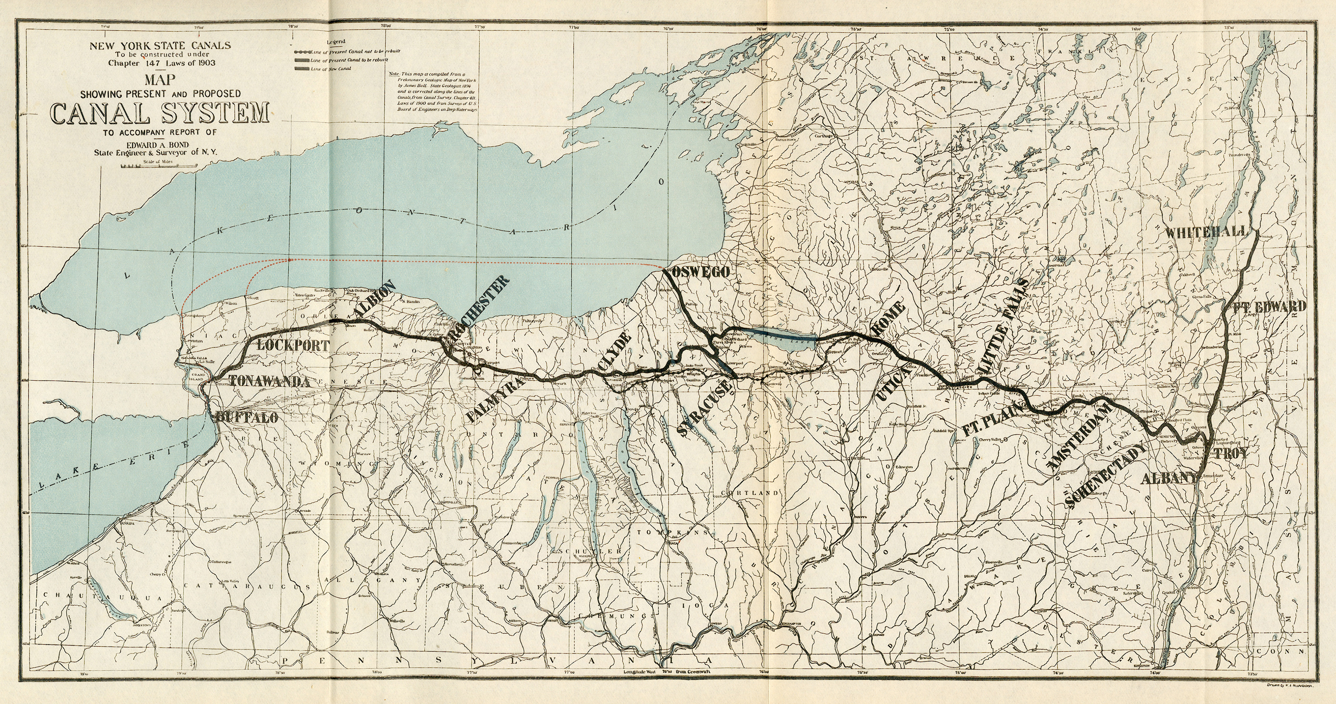
The Erie Canal is huge.  Not necessarily in dimensions - it was only four feet deep and often just 40 feet wide, though it does span 363 miles from end to end.  However, it is really huge in that it was an massive government public works undertaking, criticized and ridiculed, that paid for itself in a short amount of time and contributed in countless ways to the development of the United States.  Stand with William Least Heat-Moon (LHM) on the edge of the canal, imagine the packet boats filled with people and barges filled with goods towed by mules and horses, and learn more about this amazing piece of our history.  To find my approximation of where LHM stops at the canal, duck your head at the low bridge as you travel to the map.

Book Quote

"The canal, only four feet deep in its early years, had become a rank, bosky froggy trough.  But it was that forty-eight inches of water that did so much to open western New York and the Midwest to settlement and commerce....

"From Lake Erie to the Hudson River (363 miles, 83 stone locks, 13 aqueducts) the canal moved people and things between the middle of the nation and the ocean; it was this watercourse, as much as anything else, that made New York City the leading Atlantic port.  Travelers who had some money could take a packet boat with windows and berths, while poorer immigrants heading into the Midlands rode cheaper and drearier line boats.  Ten years after Clinton's Folly opened, the populations of Syracuse, Rochester and Buffalo increased three hundered percent; the canal, having paid for itself in that decade, had changed the northwest quarter of America.  No paltry accomplishment for a scheme that even the visionary Thomas Jefferson saw as a little short of madness."

Blue Highways: Part 8, Chapter 6

The Erie Canal near Rome, New York. Photo by "genewest" and hosted at Panoramio. Click on photo to go to host page.

Somewhere on the Erie Canal

When I was in grammar school, we still had some music education in the public schools.  It didn't happen often, maybe once a week, but it usually involved some kind of percussion playing and/or singing.  I think we had a guest teacher who would come in and lead these sessions.

I remember that the song book with which we worked had patriotic songs, and I remember that there were a couple of folk songs in there that I liked, but which I can't really remember so many years distant.  John Henry might have been one of them, or at least it comes to mind.

The one snippet of song that I remember from that book is this:

Low bridge, everybody down,
Low bridge, 'cause we're comin' to a town.
And you'll always know your neighbor,
You'll always know your pal,
If you ever navigate upon the Erie Canal.

Why I remember this one lyric, I can't say.  After all, there were more recognizable songs in that book.  There were other tunes in that book that were fun to sing.  Yet I've always kept that lyric about the Erie Canal in my head.

The Erie Canal is one of those massive efforts in our history that shouldn't be forgotten, but the benefits of which are not often considered.  The concept was simple - create a waterway that joined a major river system with the Great Lakes so that development of the middle of the country could proceed.  The execution was anything but simple.  This waterway had to traverse over 363 miles of country with a total elevation rise of 600 feet, entailing inventiveness and the practical application of engineering that had never been used before.  The sum estimated to build it was considered to be almost unimaginable.  Even Thomas Jefferson, the man who sent Lewis and Clark into the interior with an instruction to look for woolly mammoths and giant sloths, thought that the project was practically insane for the time period.

Even so, it was taken up by the New York legislature and passed.  The canal became known as Clinton's Folly (after Gov. DeWitt Clinton of New York) and was widely expected to fail.  Yet it didn't.  It employed thousands of people in the construction, particularly recent immigrants in need of work, and many of whom died of disease in marshes.  At the time, the United States had no civil engineers, so it literally created the practice of civil engineering in the country.  The builders of the canal, with no practical experience, had to solve problems like marshes and escarpments that stood in the way of joining the Hudson River with Lake Erie.  The Canal also utilized new inventions, like hydraulic cement, to solve problems such as leaks.

How did the Canal work?  Draft animals such as mules or horses pulled barges and packet boats by walking along a towpath alongside of the canal.  There was only a towpath on one side of the canal, so when boats met each other, one draft animal would move toward the canal side of the towpath and the other toward the far side of the towpath.  The mule or horse team at the far side would stop and let the boat float, causing the towline to go flat, and the other team would step over it and continue on.

This was a public works project that yielded enormous benefits to the benefits to the fledgling nation.  American inventiveness and ingenuity were suddenly the envy and marvel of the world.  New York City became the preeminent port on the Atlantic, spurring competition in cities like Baltimore and Philadelphia.  According to A.K. Sandoval-Strausz, in his comprehensive history of the hotel, the increased opportunities of transport led to a rash of hotel building throughout the United States.  Some estimate the Canal led to savings in transport costs of up to 95 percent.  People and goods had to travel by animal drawn wagon before the Canal was built.  If you consider that it was estimated that a team of four horses could pull one ton twelve miles to eighteen miles a day, depending on the road, but 1000 tons for 24 miles over water, you can see just how effective the Canal was in increasing commerce into the interior.  The accompanying surge in population to the Midwest was an added benefit to a country that saw itself with a Manifest Destiny.

I am intrigued, in this day and age when government spending on public works is attacked as wasteful, how much good this governmental outlay of capital on such a project caused so much good.  We are in a period where government can do no right, and certainly there were many doubters about the Erie Canal, yet the expense worked to the betterment of the nation.  I am especially intrigued because, probably even more than now, the country had an immigrant problem.  Hundreds of thousands of immigrants were flocking to the United States and settling in slums in major cities.  The construction of the Erie Canal allowed them to find work, as well as moving them out of the slums and into areas where they could settle.

In New Mexico, the state government is almost finished on a project called Spaceport America.  I almost see the idea as being analogous to the Erie Canal.  As the federal government ramps down its spending on NASA, there is a push for private industry to step in and fill the gap by providing service to the International Space Station and other space initiatives.  There is also expected an accompanying rise in space tourism.  When my wife and I took a tour of the Spaceport facilities, the tour guide was positively gushing about the private sector role, and very negative about government.  The message was that government doesn't do any good, and should stay out of the private market.  My wife was moved to remind him that without government spending, the Spaceport would not have been built at all, and that government spending can often spur additional private spending.  The guide then modified his rhetoric to agree, but then argued that government should then get out of the way.

As I see all the problems facing this country as I write, including a crumbling infrastructure, a large unemployment rate, and questions about immigration, I see a place for government spending.  I may be revealing my political stripes, and readers are free to disagree, but of course I live in a state that lives or dies by government spending on military bases and research, federal lands, and reservations.  But, it is very telling to me that some of the United States' biggest accomplishments could only come about by government being willing to spend money where a need was perceived, often regardless of how that expenditure was seen by the public, and often with spillover results that yielded benefits beyond the initial project.  I'm willing to admit that government is not always positive, but often it is.  Just look at the Erie Canal and its place in our history.

Musical Interlude

The Erie Canal song was written by Thomas Allen in 1905 after Erie Canal traffic switched from draft pulled barges to engine-powered barges.  It is a piece of nostalgia about loss of a way of life and change in an increasingly mechanized society.  In this version that I found, the song is performed by no other than Bruce Springsteen, off his tribute to Pete Seeger in his album We Shall Overcome: The Seeger Sessions.  The song was recorded live in Dublin, Ireland which adds an additional link - at the time many Scots-Irish immigrants to the United States were employed in building the canal (there is also a recording of Springsteen doing the song in Belfast, Northern Ireland which would have been even more appropriate, but it is not as good as this recording).  This is the song that I sung in grammar school, but probably not as good as Springsteen and his band.

If you want to know more about the Erie Canal

Building the Erie Canal
The Erie Canal: A Journey Through the History
Erie Canal Museum
Erie Canalway National Heritage Corridor
History of Building the Erie Canal
History of the Erie Canal
New York State Canals
Scenic Historic Erie Canal Sightseeing Cruises
Wikipedia: Erie Canal

Next up: Rome, New York

Saturday
May262012

Blue Highways: Somewhere on the North Side of Oneida Lake, New York

Unfolding the Map

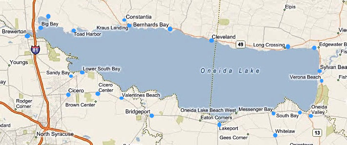
As we continue through New York, we happen with William Least Heat-Moon (LHM) upon Oneida Lake, the largest freshwater lake entirely within the state.  This post is about framing, or specifically how a lake helps visually frame vistas.  But it is also about something more.  Books like Blue Highways frame an author's perspective and thoughts, and now I'm using these posts to frame my experience of Blue Highways and other books for you.  Hopefully, you can use my posts to frame your own thoughts and create frames of perspective for others.  To frame Oneida Lake geographically, please see the map.

Book Quote

"The shingled cafe, Ben and Bernies, afforded a broad view of Lake Oneida....

"The Oneida shoreline was warm - too warm - for May, although maples by the highway had opened to a cooling shade.  The perpetual spring I'd been following around the country was about done.  On a map, Lake Oneida looks like a sperm whale, and my course that morning was down the spine, from the flukes to the snout.  All along the shore, old houses, big houses, were losing to the North climate, and for miles it was a place of sag and dilapidation."

Blue Highways: Part 8, Chapter 6


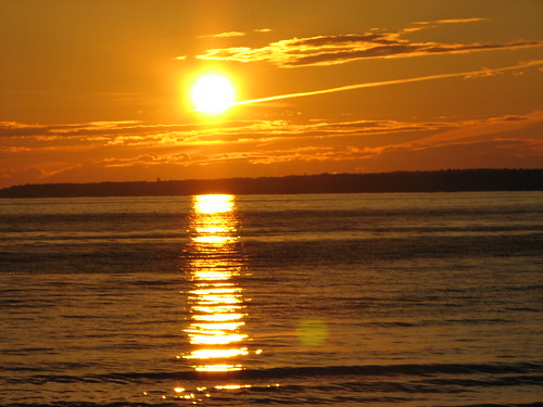
Sunset over Oneida Lake, New York. Notice how water, land, sky and sun work together so well in this picture. Photo by The Brit_2 and hosted at Flickr. Click on photo to go to host site.

Somewhere on the North Side of Oneida Lake

I've always heard that when one takes a picture, framing the shot is the most important thing one can do to make sure that the picture is a good one.  I've also watched videographers, and have seen television shows about how certain movies are made, and once again how shots are framed are very important.

What is framing?  In photographic terms, framing focuses the viewer's attention on an object in the photo or in the scene, and in many cases can add a sense of depth to an image.  So, why am I starting out a post centered on Oneida Lake with the concept of framing?  I think I first became aware of this component of visual arts through my interaction with lakes.

I grew up next to the Pacific Ocean.  When one looks west from my hometown, the ocean spreads flat as far as the eye can see.  On some days, the view is to the horizon and on other days, if it is foggy, the eye cannot see as far.  When looking out over the ocean, one seeks some kind of frame of reference, such as a boat or other object.  I often found my eyes seeking the coastline, especially north where Cape Mendocino juts out into the ocean many miles distant, and I often found that a pleasing sight as it gave me a sense of distance and depth that I lacked looking straight west.

I probably had my first experience with a lake when I was too young to remember.  My family used to make yearly winter trips from our home on the ocean to Lake Tahoe.  They started this before I was born, and for some reason these trips ended when I was about four years old.  I do not remember much about my couple of trips to Lake Tahoe at the time other than some disjointed images of the car ride and being in snow (which I hated at the time because I didn't like the cold).

The first time I remember seeing a lake and really appreciating it was when I was in junior high school.  I was probably in 8th grade.  I had a friend named Mike, and he lived with his mother.  His father lived in Clearlake, California and Mike asked me if I would like to go with him to see his dad for the weekend.  His dad was a pilot, and flew over to Little River Airport to pick us up.  It was my first airplane ride, and as we followed Highway 20, which I knew well, I saw the limits of my world laid out for me.  I noted the turn from Highway 20 onto U.S. 101 and followed its line down toward Ukiah - the route I knew so well from frequent trips to the orthodontist and the ophthalmologist.

Just beyond a low hill from U.S. 101, where I wouldn't have seen it from the road, lay a small lake.  I asked about it, and learned it was Lake Mendocino, a large reservoir on the east fork of the Russian River.  We were following Highway 20 again after it split off from 101 - a continuance that I wasn't aware of.  There were a series of little lakes that followed along the road.  I was told those were the Blue Lakes, and told some thought they were bottomless.  Then, a much, much larger lake, Clear Lake, came into view.  As we banked over and began our approach into Clearlake's airport, I was amazed by its size.

Since then, I have seen a number of lakes, some much bigger than Clear Lake, and have realized that everything is perspective.  And to be fair to myself, Clear Lake is the biggest body of fresh water entirely in California.  But at that time I never realized that there could be a volume of water, outside the ocean, that could be so big.

The time we spent on and around Clear Lake was fun.  Mike's dad owned a motel with a pier into the lake and we spent time fishing, and he took us out in his boat and I learned to water ski for the first time.  But what made the lake so fascinating was the view.  Mount Konocti, a volcano, rises on the south shore of Clear Lake, and small hills ring it.  The depression in which the lake lies and the flat blue water of the lake itself creates a natural frame.  I think that my unconscious view was drawn to this frame of water, earth and sky and I would spend a lot of time looking toward the lake for that reason.

I've seen this effect at other lakes as well, including in New York where LHM travels first past the Finger Lakes and then past Oneida Lake.  On a visit to a friend's parents' house at Geneva, New York, I was aware of a similar effect as I looked south down the long lake.  Hills and sky frame the lake, and if an object such as a sailboat were on the lake in the distance, the combination of elements framed the boat beautifully.

I can imagine LHM coming upon Oneida Lake for the first time.  The water appears, and the frame spreads as more water fills the field of vision and the shores spread out to the right and left.  Depending on the time day, the sun might add to the effect.  At dawn, as the sun rises, a trail of light might direct one's gaze toward where the sun is coming up if one is standing at the western end of the lake.  One might see the same effect in the evening at the eastern end of the lake.  The lake is long enough that one might not be able to see completely across its length, which in itself creates a frame for the eye.  At the same time, standing on the north shore, the length of the south shore (if it can be seen - I don't really know) would draw the eye toward natural frames that the brain would recognize, giving depth and distance a meaning.  I'm speculating, because I have never been to Oneida Lake, but that's the point of a book - to put these images in my mind that tap into my own experience.

I've always been one to really observe and see the art and beauty in the world around me.  Some of my most memorable scenes, ones that are indelibly etched into my experience, are the vistas surrounding lakes, and I believe it is because of that natural framing that occurs that my unconscious, developing mind recognized and appreciated long before my conscious mind understood why.

Musical Interlude

The lyric "In and around the lake, mountains come out of the sky and they stand there" came into my mind as I was writing this post.  To me, it almost perfectly encapsulates the effect a lake can have on one's vision.  The lyric is from the song Roundabout by Yes.  The rest of the lyrics can be seen if you go to the YouTube site for the video.

If you want to know more about Oneida Lake

New York Department of Environmental Conservation: Oneida Lake
Oneida Lake
Oneida Lake, New York
Wikipedia: Oneida Lake

Next up:  Somewhere on the Erie Canal

Thursday
May242012

Blue Highways: Conquest and Cato, New York

Unfolding the Map

If you're a map lover, or you like stories about where towns get their names, or you are into irony, then there's something of each in this post.  If you love all three, you've hit the jackpot!  We'll pass through Conquest and Cato with William Least Heat-Moon (LHM), and then move on.  But before we do, see where these places are located by referencing the map.

Book Quote

"Off I went, hoping Conquest would find me.  In the dairy country, chewing Holsteins and Guernseys switched their tails and flicked their skins.  On the other side of Johnny Cake Road lay Conquest.  Then I began the game again, looking for Cato.  Along the roads were cottage industries selling clothesline poles, purple martin houses, potted plants, AKC pups."

Blue Highways: Part 5, Chapter 8

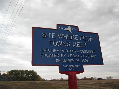
Sign depicting the intersection of Cato, Ira, Victory and Conquest, New York. Photo by "Dougtone" and hosted at Flickr. Click on photo to go to host page.

Conquest and Cato, New York

Sometimes you wonder how towns got their names, especially if those names are interesting.  Many towns are named in honor of people, some are taken from place names already in the area, some are named after cities of antiquity.  In fact, as we travel with LHM through this area, we'll find cities like Palmyra, New York, named after an ancient city in Syria, and Syracuse, New York, named after a city established by the ancient Greeks on the island of Sicily.

I have two directions that I'm going to go in this post.  One of my previous posts explored city names with an ironic twist.  In the case of Conquest and Cato, there is an irony.  I think that LHM thought he was looking at a little bit of irony when he mentioned in Blue Highways that Conquest is just down the road from Victory.  But there's even more irony here than that, but it's a little convoluted.

First, Cato.  Cato is one of a number of towns established in a large tract of land, called the Central New York Military Tract, that was reserved for ownership and settlement by New York veterans of the Revolutionary War.  The idea of setting land aside was conceived by the U.S. Congress to compensate veterans, and was to consist of 100 acres of land per soldier.  However, New York was slow in getting this land together, so the state legislature set an additional 500 acres per land, for a total of 600 per soldier, in a series of 28 contiguous townships in the middle of the state.

The townships were allegedly named by a clerk in the New York Surveyor General's office, who was an avid reader of classical literature.  Thus, the township name of Cato was joined by other townships named Lysander, Hannibal, Brutus, Camillus, Cicero, Manlius, Aurelius, Marcellus, Pompey, Romulus, Scipio, Sempronius, Tully, Fabius, Ovid, Milton, Locke, Homer, Solon, Hector, Ulysses, Dryden, Virgil, Cincinnatus, Junius, Galen and Sterling.

Conquest was a settlement within the township of Cato, but became independent of Cato after a political dispute.  Upon achieving their desired political aims, Conquest immediately declared victory by starting a new town called Victory, and later giving LHM something to wonder about when he sees the two places on the map.

However, the Cato-Conquest-Victory saga is not free of irony yet.  Cato Township could have been named after Cato the Elder, a Roman military commander and statesman.  If that were the fact, then Cato Township having birthed Conquest and Victory has no irony whatsoever.  However, it is more likely that the township of Cato was named after Cato the Younger, a Roman statesman and philosopher of the school of Stoicism.  As a Stoic, Cato the Younger would have held the belief that emotions can be destructive forces, especially if used to try to control inevitable universal forces, and that reason and ultimate happiness came from keeping oneself under self-control and evincing fortitude.  One cannot control what the universe and should not try, and if one is virtuous and in control, one is immune to misfortune.  The early Greek Stoics even eschewed politics because they believed in cosmopolitanism - that one is a citizen of the greater world and not just of one political entity.  Thus, the irony.  The town of Conquest was born out of political dispute with the township of Cato, complete with the investment of anger on both sides, and is an example of petty and small political concerns over brotherhood and equality that Cato the Younger would have emphasized.

That's an interesting little story, but here's the other point I want to make in this post.  Many place names in the United States are derived from ancient Greece and Rome, or from Europe.  This makes sense, as the U.S. is a nation of immigrants.  Therefore, the first English settlers on the East Coast gave their towns and states and regions names that evoked their homeland, such as Dover (Delaware), Cambridge (Massachusetts), Camden (New Jersey), New York City, and Plymouth (North Carolina).

Of course, other ethnic groups that made up this country named areas that evoked their own homes.  We have many place names in the Southwestern U.S., for instance, that are Spanish.  Germans added places in the U.S., often multiple times, as Berlin, Potsdam, Hamburg and Hanover.  Names that evoke Italy include Milan (multiple states), as well as Rome (multiple states), Naples (Florida), Venice (multiple states), and Florence (multiple states).

New York was New Amsterdam in its early years as a Dutch settlement on Manhattan.  In the middle of Texas, you can find Czech town names.  French place names are found all over the United States, given that much of the middle part of the country was explored by French explorers and trappers.

It all makes me wonder, given that the United States is in a period where it is the preeminent power in the world, if that a thousand years from now the names of our great personages will dot the globe.  Will we see a village, town or city of "Gates" spring up in China, or a "Jobs," India?  Will someone name a town after Jefferson in Africa (the capital city of Liberia, Monrovia, is named after President James Monroe)?  Will the U.S. even have people, academicians or politicians or celebrities or captains of industry, who are deemed important enough to name places after in other parts of the world?

Let's take our query a little further.  Will the U.S. have enough impact on the world that someday we will see a New Chicago spring up in another country?  Will a Houston or Dallas appear in some other region of the world to one day rival the memory of their American forebears, just as New York dwarfs Old York, and Boston, Massachussetts is more well known than its English namesake.  Does the United States have anything to offer the world so that even one day, when our empire crumbles as it will, as it must, some place names will evoke the country that pioneered a working, large scale democracy for the world?  Or will something happen that causes American emigration - a huge diaspora to other regions of the world - so that those peoples, in foreign lands, remember their lost homeland by naming their settlements and towns after the places they left?

We see the remnants and memories of some past great civilizations every day in the names that we have chosen to give to places in the U.S.  When our time is past, will we be worthy of such remembrance, or will we fade into obscurity like other civilizations whose memories are locked in museums and books.  It's interesting to think about and speculate.

Musical Interlude

I'm not sure why I thought of this song, I Don't Wanna by the Asylum Street Spankers, except that it has a lot of place names in it.  It's a catchy tune, though.

How many of the place names in the song do you know or have you been to?  See bottom of page.*

If you want to know more about Conquest and Cato

An 1879 History of Conquest
Town of Conquest
Village of Cato
Wikipedia: Town of Cato
Wikipedia: Village of Cato
Wikipedia: Conquest

Next up: Somewhere on the north side of Oneida Lake

*Place names in song:  Scotland, Wales, England, France, Moscow, Malta, Spain, Cuba, Brooklyn, Paris, Rome, Teapot Dome, Orleans, Cairo, Broadway, 21, India, Georgia, Pismo Beach, Smithfield, China, your house.