Current Littourati Map

Neil Gaiman's
American Gods

Click on Image for Current Map

Littourari Cartography
  • On the Road
    On the Road
    by Jack Kerouac
  • Blue Highways: A Journey into America
    Blue Highways: A Journey into America
    by William Least Heat-Moon

Search Littourati
Enjoy Littourati? Recommend it!


Littourati is powered by
Powered by Squarespace


Get a hit of these blue crystal bath salts, created by Albuquerque's Great Face and Body, based on the smash TV series Breaking Bad.  Or learn about other Bathing Bad products.  You'll feel so dirty while you get so clean.  Guaranteed to help you get high...on life.

Go here to get Bathing Bad bath products!

Entries in Arizona (18)

Saturday
Apr092011

Blue Highways: Polacca, Hopi Reservation

Unfolding the Map

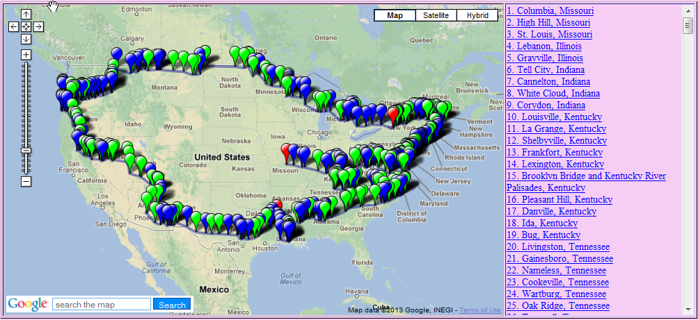
Click on Thumbnail for MapWe are now traveling with William Least Heat-Moon (LHM) through miles and miles of reservation.   We are still in Arizona, but we are on sovereign nations within the state. We pass through the Navajo Nation and in the middle of it, we find the Hopi Reservation.  We'll slow down as we pass by Polacca, and think about how tribes like the Hopi are trying to preserve their culture and teach others about it, all while holding on to those things that ensure their ways of life and traditions will last.  To see where we've come, click on the map thumbnail at right.

Book Quote

"Although the Hopi have lived here far longer than any other surviving people and consider their mile-high spread of rock and sand, wind and sun, the center of the universe, they are now, by Anglo decree, surrounded by their old enemies, the Navajo, a people they see as latecomers.

"Holding on to their land has been a long struggle for the Hopi....But recently they have fought Navajo expansion in federal courts, and a strange case it is:  those who settled first seeing judgment from those who came later thorugh laws of those who arrived last.

"Because the Navajo prefer widely dispersed clusters of clans to village life, I'd seen nothing resembling a hamlet for seventy-five miles.  But Hopi Polacca almost looked like a Western town in spite of Indian ways here and there:  next to a floral-print bedsheet on a clothesline hung a coyote skin, and beside box houses were adobe bread ovens shaped like skep beehives.  The Navajo held to his hogan, the Hopi to his oven.  Those things persisted."

Blue Highways: Part 5, Chapter 2


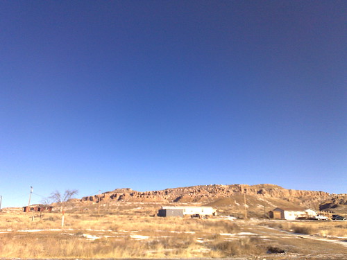
Photo taken at Polacca, Hopi Reservation, by Marc Davis. It can be found on his photostream at Flickr. Click on photo to go to the site.Polacca, Hopi Reservation

Though I've never been on the Hopi Reservation, I have been on the Navajo Reservation that surrounds it when my wife and I camped at Canyon de Chelly and made two tours down into the canyon.  That doesn't tell me anything about the Hopi people because as LHM suggests, the Navajo and the Hopi are two different peoples and are historic enemies of one another.  My understanding of the Navajo, which may be wrong, is that they tend to be a pastoral and nomadic people that are relatively solitary.  That doesn't mean they couldn't be violent in the past, and they were known to raid other tribes and white settlers in the area.  However, like most other Indian tribes, they were constantly deprived of more and more land whenever the U.S. government renegotiated treaties.  Living in New Mexico, one is constantly reminded of the role that Kit Carson played in New Mexico history, one of which was the Long Walk, a sad and outrageous act of forcing the Navajo off of their tribal lands and compelling them to travel by foot to eastern New Mexico, a trip of 18 days.  There, they were forced to live for four years before being allowed to return to their homes.

The Hopi, as I understand, are related to the pueblo Indians of New Mexico and are the earlier inhabitants of the region.  I am more familiar with the pueblo peoples because I've had more experience of their history and culture.  The Hopi differ from the Navajo, it seems to me, in that they are particularly tied to their place, the three mesas upon which they live.  They speak their own particular language that is unrelated to the language groupings of the other puebloan peoples, and within their language they have at least four dialects.

I have visited three pueblos: Acoma, Zuni and Taos.  I've only passed by or through some others.  These pueblos are interesting in terms of their adobe dwellings, which were almost like apartments in that singular dwellings adjoined and attached other dwellings both horizontally and vertically.  Each pueblo can be distinguished by many things, including its artwork such as pottery and jewelry.  Zuni inlay jewelry, for instance, is an amazing thing to behold and continually fascinates me when I see it.

Many of the Puebloan peoples claim descent from the Native people that built and maintained the amazing community and religious complex at Chaco Canyon, a place that made a huge impression on me when I visited.  The mysteries of this place are still being uncovered, but the scale of the ruins and their perfect alignment with the paths of the sun and the moon are incredible for a people without modern sighting equipment.  The remains of roads have been excavated that run remarkably straight over mesas and down and up cliffs to connect distant and far flung villages to the main religious and community areas of Chaco Canyon.  If a cliff created an obstacle, then the Chacoans simply carved "staircases," little more than handholds, into the cliff.

Nowadays, some of the pueblos seeking the tourist dollar have slick and well-developed tours.  I'm not sure if the Hopis have created that yet, but Taos Pueblo with its three and four story adobe apartment buildings, and Acoma Pueblo situated 300 feet high above the valley floor on a small mesa, have really honed the art of giving really nice, informative tours and enticing people to buy native arts crafts as well as learn something of their culture.

However, one of my best pueblo experiences was at Zuni, which has definitely not developed its tourism too much yet.  We rode on a bus from the Pueblo Cultural Center in Albuquerque to Zuni, about three hours west, and took a tour of the village.  There was a church with amazing kachina art inside that is in danger of decay.  A walk through the village showed both the ancient and the modern as we viewed the unpaved town square where, at the time, cars and trucks passed through occasionally but during festivals would be lined with rows of people, some even congregated on rooftops.  We passed down a way where Zuni women still used the horno, the adobe oven borrowed from the Spanish (who borrowed it from the Moors), to bake amazing mouth-watering loaves of bread.  The tour was simple, comprehensive, and really focused on a way of life that, as in all tribes, is in danger from modern influences. 

I loved it.  I hope that the Hopi people have found a balance between tourism and their traditional ways of life.  Even as they are surrounded by their ancient enemies, and subject to a government that has shown throughout its history at best a lack of caring for native peoples and at worst a rapaciousness toward their lands and belongings, I hope that if I were to ever visit the mesas I would see a people able to take the best of what modern life can bring without losing what defines them.

Musical Interlude

I found this song on YouTube, sung by a Hopi elder and medicine woman named Roanna Kagenveama, called the Hopi Women's Eagle Song.  She is from Polacca.  Let her voice bring you with us to the windswept Hopi homeland.

If you want to know more about Polacca or the Hopi

Hopi Cultural Preservation Office
Official Website of the Hopi Tribe
Wikipedia: Hopi
Wikipedia: Hopi Reservation
Wikipedia: Polacca

Next up:  Hopi Cultural Center, Hopi Reservation

Thursday
Apr072011

Blue Highways: Holbrook, Arizona

Unfolding the Map

Click on Thumbnail for MapWe cross an interstate and consider Holbrook, Arizona - the only town, I'm sure, with a street called "Bucket of Blood."  Are there interesting attractions to be seen on the interstate?  Or do we need to get off the beaten path?  Pull off the road, get a room at the Wigwam, and think about it.  Click on the map thumbnail at right to see where Holbrook sits.

Book Quote

"Holbrook used to be a tough town where boys from the Hash Knife cattle outfit cut loose.  Now, astride I-44 (once route 66), Holbrook was a tourist stop for women with Instamatics and men with metal detectors; no longer was the big business cattle, but rather rocks and gems."

Blue Highways: Part 5, Chapter 2


The Wigwam Motel in Holbrook, Arizona. Image located at unusualhotelsoftheworld.com. Click on image to go to site.

Holbrook, Arizona

First, a little bit of a correction.  LHM in his quote above says that Holbrook sits astride I-44.  In actuality, Holbrook is on I-40.  I-44 is an interstate that runs from St. Louis to Wichita Falls, Texas.  He may have changed this in later editions of the book, but I'm not sure.

Now that we have our interstates straight, what can we say about Holbrook.  Though I've traveled past it, I've never stopped.  However, I know that it has a great old 50s motel that kind of defies LHM's wistfulness about the loss of hotels to motels.  One may never say that they have gotten the chance to stay at a "grand" motel, but they may get the chance to say that they stayed in a unique motel.  The wigwams that make up the Wigwam Motel are pretty fun and eyecatching as you drive by them.

This makes up part of a familiar theme that I've come back to time and again.  The interstates, in many ways, really took the adventurousness out driving.  Now we drive fast to get places.  But back in the 50s, before the interstates were pushed through towns and cities, people drove on trips down two-lane highways like Route 66 which, as the famous song points out, "winds down from Chicago to L.A.," to see interesting things while they were driving.  The car was mass-produced like never before and more people were driving places that they had never been.  Entrepreneurs, eager to cash in on the number of people doing leisure driving, put up fun and interesting roadside attractions, eateries and places to stay that were supposed to catch people's attention.  In the West they played on Western themes like cowboys and Indians, prospectors and mines, and other Western things.  Only a few of those types of attractions, like the Wigwam Motel, still exist.

Occasionally, you can still find these roadside attractions, though I think they are probably a mass-consumer version of what they once were.  The famous Wall Drug signs all over the country that advertise and converge on a roadside stop in South Dakota are replicated in smaller versions in the rest of the country.  During my frequent drives between Lubbock, Texas and Albuquerque when I taught at Texas Tech, I passed miles of billboards advertising the Flying J Ranch and the rest stop at Clines Corners.  The signs advertised gems, pottery, beads, moccasins, fireworks, ice cream, food ("eat here and get gas" the Flying J's signs proclaimed), and other automotive, digestive, and vanity concerns.  Going into them, however, put me in just another kitsch shop, with silly and cheap souvenirs, fudge and country music selections.  The effect was the same as visiting the Mars Cheese Castle in southern Wisconsin - same kitsch, different state. 

I guess that's what LHM was getting at when he speaks of the "rocks and gems" that seem to be the attraction of the day.  How many people, passing through on the interstate and making a quick stop at a rock shop with all kinds of tchochkes, would note that Holbrook has a street called "Bucket of Blood" street.  How many would be curious enough to wonder where that name came from?  Hint: it had to do with the cattle wars of the late 1800s and Holbrook's former reputation as a rough place due to the Hashknife gang that LHM mentions frequented the place.

I suppose it's the reason why LHM takes blue highways.  I try when I get a chance.  By doing so, one can try to find something left of an America that is rapidly disappearing as people become more homogenous in their preferences.  I hope that somewhere pockets of America still exist that are different enough to be interesting.  I felt I found that type of different-ness in New Orleans, but somewhere out on the highways I know more such places must exist, perhaps around a turn past the McDonalds or in some geologic depression just out of sight of the interstate.  It doesn't have to be a Shangri La, just something different than what's become...normal.

Musical Interlude

One of the best road songs ever written - an ode to a road that's gone.  The Nat King Cole Trio did one of the first and one of the best versions of the song Route 66, in my humble opinion.  Listen and "get your kicks!"

If you want to know more about Holbrook

AzJournal.com (newspaper)
DesertUSA: Holbrook
City of Holbrook
Petrified Forest National Park
White Mountains Online: Holbrook
Wikipedia: Holbrook

Next up:  Polacca, Hopi Reservation

Monday
Apr042011

Blue Highways: Snowflake, Arizona

Unfolding the Map

Click on Thumbnail for MapWilliam Least Heat-Moon passes through Snowflake, an oddly named town in Arizona - at least I thought so in my teenage ignorance.  Where in the heck would a town named Snowflake be located in Arizona?  Click on the map thumbnail at right and you'll see!

Book Quote

"Tuesday morning: the country east of Heber was a desert of sagebrush and globe-shaped junipers and shallow washes with signs warning of flash floods. I turned north at Snowflake, founded by Erastus Snow and Bill Flake, and headed toward the twenty-five thousand square miles of Navajo reservation (nearly equal to West Virginia) which occupies most of the northeastern corner of Arizona. The scrub growth disappeared entirely and only the distant outlines of red rock mesas interrupted the emptiness. But for the highway, the land was featureless."

Blue Highways: Part 5, Chapter 2


Downtown Snowflake, Arizona. Photo by Ken Lund and located on his photostream at Flickr. Click on photo to go to site.

Snowflake, Arizona

Back when I was in high school, my friend John said that his brother was moving to Snowflake, Arizona to teach school.  This was probably about the time that LHM drove through Snowflake on his around the country trip.

As a kid who had left California only once up to that point, I didn't really have a very good sense of geography.  I thought I did.  I could find Arizona on a map - in fact I loved maps and if given a chance I would peruse them for hours.  Whatever I had read about Arizona had always called it a dry and arid state.  Every day in the summer it seemed that Phoenix had the highest temperature of the day, usually well over 100 degrees, and sometimes well over 110.  Arizona deserts were often referred to in books and magazines.  Movies didn't give any other impression than a dry place.

In other words, the idea of a Snowflake, Arizona didn't really fit in with my cognitive map of Arizona.  Arizona, to me, was a snowflake's idea of hell.  If one could fry an egg on a sidewalk in Arizona, how could anyone associate Arizona with frozen precipitation?  I began to assume that Snowflake was in fact an ironic name, a joke name, given by thirsty people with a wish that would never be fulfilled.  I would even get a little sarcastic lilt in my voice whenever the subject of John's brother would come up.  "You mean, the one in Snowflake, Arizona?" I would ask, drawing out the name of Snowflake a little.  To me, it was almost as if John's brother was teaching in Brigadoon, Camelot or some other imaginary, fantastical place.

Of course, a little more knowledge about topography would have been helpful.  Growing up at sea level, I never considered elevation and that Arizona could be something more than a flat desert.  Having driven through the state a few times now, I am amazed by the varieties of topography and the extent of elevation changes.  When I drove to California from Albuquerque through Arizona, we left Albuquerque at 5000 feet and by the time we hit the highest point on Interstate 40 near Flagstaff, Arizona, we were at about 7000 feet above sea level before the long, slow descent to the coast.

Snowflake sits at about 5500 feet, and actually gets cold winters with snow, so I've read.  All that sarcasm wasted!

But now, here's the interesting and, in a way, slightly disappointing part to me.  Snowflake was not actually named because of its abundance or lack of snowflakes, but because the name is derived by combining the last names of the two Mormon pioneers that founded the town - Erastus Snow and William Flake.  On one hand, it makes a good story.  On the other hand, however, it once again jars with my cognitive map.  A town like Snowflake that gets snow should have a name that reflects the realities of the weather, right?  Here's the new irony for me - Snowflake actually makes sense given the town's elevation and weather, even though the name itself had nothing to do with those things at all!

As I sit writing this, I still find it funny and ironic that Snowflake continues to intrigue me all these years later.  I graduated from high school almost thirty years ago.  My friend John and his family, members of the Mormon Church, have all resettled in Utah and Wyoming.  His brother Steve has long since left Snowflake.  And yet, when I look at a map, I'm still fascinated by this town name that seems to fit this town, but never quite fit into my own conception of geography and place.

Musical Interlude

While you're looking for more information about Snowflake, if that's what you are really doing, use Claude Thornhill's ethereal composition Snowfall as mood music.  I'm sure that Snowflake has this feeling once in awhile!

If you want to know more about Snowflake

City of Snowflake Visitor Information
Snowflake, Arizona Home Page
White Mountains Online: Snowflake
Wikipedia: Snowflake

For science fiction and alien abduction buffs, the vicinity around Snowflake served as the setting for the alleged UFO abduction of Travis Walton.  He chronicled his experience in the book The Walton Experience, which was made into a movie: Fire in the Sky.

Next up: Holbrook, Arizona

Saturday
Apr022011

Blue Highways: Heber, Arizona

Unfolding the Map

Click on Thumbnail for MapWilliam Least Heat-Moon (LHM) bemoans the decline of hotels in America.  There's not much on the internet about Heber but since when has that stopped us from perusing, pondering, questioning and answering?  We'll think a bit about what the hotel was and has been and what it is today.  Click on the thumbnail of the map at right to place Heber on your mental geography.

Book Quote

"....I began anticipating Heber, the next town.  One of the best moments of any day on the road was, toward sunset, looking forward to the last stop.  At Heber I hoped for an old hotel with a little bar off to the side where they would serve A-1 on draft under a stuffed moosehead; or maybe I'd find a grill dishing up steak and eggs on blue-rimmed platters.  I hoped for people who had good stories, people who sometimes took you home to see their collection of carved peach pits.

"That was the hope.  But Heber was box houses and a dingy sawmill, a couple of motels and filling stations, a glass-and-Formica cafe.  Heber had no center, no focus for the eye and soul: neither a courthouse, nor high church steeple, nor hotel.  Nothing has done more to take a sense of civic identity, a feeling of community, from small-town America than the loss of old hotels to the motel business.  The hotel was once where things coalesced, where you could meet both townspeople and travelers.  Not so in a motel.  No matter how you build it, the motel remains a haunt of the quick and dirty, where the only locals are Chamber of Commerce boys every fourth Tuesday.  Who ever heard the returning traveler exclaim over one of the great motels of the world he stayed in?  Motels can be big, but never grand."

Blue Highways: Part 5, Chapter 1

US Post Office at Heber, Arizona. Photo on "thornydalemapco's" photostream at Flickr. Click on photo to go to site.

Heber, Arizona

My family rarely traveled very far when I was growing up, so I really didn't gain an appreciation for hotels.  What I did gain was a sense of their utilitarianism; when we drove down to what used to be Marriot's Great America in Santa Clara, California we used the room for sleep and changing, and we used the pool for swimming.  Otherwise, we really didn't stay there much.  When we were traveling, the motel was where we slept.  In my home town, the buildings that were called hotels were somewhat dark and dingy, with scary bars.

My wife, whose father was a university president, has a much better appreciation for hotels than I do.  When she grew up, her parents traveled with their kids a lot, and they stayed in hotels all over, such as the Palmer House Hotel in Chicago.  She loves old hotels that have managed to stay in business, and if we see one, we usually have to wander in and check out the lobby and its decor.  Sometimes, she'll even book us into one for a stay.  It's at these times that I can appreciate what my wife sees in hotels - the comfort and home-away-from-home feeling.  Sometimes, it's even the opulence that makes one feel like he or she is staying in a castle, a place worthy or royalty.

LHM foreshadows by many years in his quote about the lack of a hotel in Heber, and the decline of the hotel in America in general, a book called Hotel: An American History by University of New Mexico associate professor and historian A.K. Sandoval-Strausz.  This book, possibly the first attempt to place the hotel in the context of U.S. history (it was, after all, an American invention), is an extremely interesting look at the how the hotel shaped America.  Hotels are uniquely American inventions because they grew out of an American reality and gave rise to other American institutions, such as the apartment building.  One was embarrassment, as American innkeepers realized that they didn't have public boarding suitable for the important VIPs of the day, such as George Washington.  A second was the growth of a nation westward.  As the people of the United States expanded ever outward, places were needed to feed and house tired travelers temporarily as they made their way through places, and waited for the next train or wagon to take them onward.  Third, as LHM alludes, hotels often became the anchor of settlements and towns across the nation;  a central place where communities and people passing through them came to meet, socialize, and do business.

Of course, as train travel gave way to automobiles, travel became more swift, and destinations became more far flung as the car lengthened the amount of miles one could travel in a day, a lot of old hotels gave way to the motel.  The rise of the motel and its simple rooms and amenities coincided with the decay of the old hotels except in major cities.  Many communities lost their old hotels, demolishing them in favor of new construction projects.  What LHM couldn't have seen when he wrote Blue Highways and passed through hotel-less Heber, however, was that many communities now look back on the old hotels with nostalgia.  Some are revitalizing them, maintaining the old ambience and feel of the hotel but modernizing them at the same time.  In Albuquerque, where I live, I know of at least one hotel that has been revitalized, the Hotel Andaluz downtown.  A developer here even remade an old mental institution into a new hotel, the Parq Central, that has an interesting ambience - a rooftop bar in the former medical dispensary that has the best view in Albuquerque.  Other communities are seeing their hotels rise phoenix-like from the ashes.  Famous artist Judy Chicago and her husband are remodeling an old hotel in Belen, New Mexico as their home and art studio, for example.

I am still coming to appreciate the hotel for what it was, and what it could be.  There's no question, however, that the loss of an historic building in a community that once housed a hotel is a true community loss.  Another Albuquerque story; a sad one.  The old Alvarado Hotel, a large Harvey House hotel that fronted the train tracks through the city, with architecture and furniture designed by Mary Colter, had fallen into disuse and was demolished in 1970.  On its site now stands a transportation center, the contours and outlines of which sadly recall the once stately building situated there, welcoming travelers with a bed and a meal after a long train ride.

When you travel, do yourself a favor sometime and stop in an old hotel.  Eat in the restaurant, get a beer or cocktail in the bar, or just hang out in the lobby for a while and watch the people come and go.  If you have time or money, stay for a night  It doesn't matter where you do it.  Just enjoy it, and realize it was once THE place to be.

Musical Interlude

I happened upon this video of Wilco actually singing about a hotel, in a geographically appropriate place.  Enjoy Arizona Hotel!

If you want to know more about Heber

There's not much on the internet, so I've assembled some little that I've found.  If you want to add what you know, feel free to do so in the comments!

Facebook: Heber-Overgaard page
White Mountains Online: Heber & Overgaard
Wikipedia: Heber-Overgaard

Next up:  Snowflake, Arizona

Thursday
Mar312011

Blue Highways: Payson, Arizona

Unfolding the Map

Click on Thumbnail for MapBack when I was in high school, I worked in my town's lumber mill loading trucks and freight cars with lumber.  After they stopped hiring high school kids, I got a job working security at the lumber mill, and got to see the whole plant including the huge sawmill - everything from the high jets of water taking bark off the logs to the raw unfinished lumber at the other end.  That lumber was soon set out for planing and then air-drying or kilning.  William Least Heat-Moon (LHM) brings me back to those days as he passes through Payson, Arizona.  To see our northeastward turn from Phoenix, click on the map thumbnail at right.

Book Quote

"....At Payson, a mile high on the northern slope of the Mazatzal Mountains, I had to pull on a jacket.

"Settlers once ran into Payson for protection from marauding Apaches; after the Apache let things calm down, citizens tried to liven them up again by holding rodeos in the main street.  Now, streets paved, Payson lay quiet but for the whine of sawmills releasing the sweet scent of cut timber."

Blue Highways: Part 5, Chapter 1


Payson, Arizona at the edge of the Mogollon Rim. Photo at "scheuringdesign's" photostream at Flickr. Click on photo to go to site.

Payson, Arizona

Payson seems like a place that I would be very familiar with.  I've never been there, but I think that the town would probably have a similar feel to my home town.  I believe this because LHM smelled cut timber as the sawmills whined.

Anyone who grows up in a lumber town knows that they have a culture unique to the lumber industry.  I'm sure the same applies to a town that has grown up around any industry, whether it be mining, steel, or even an agricultural center.  I know lumber towns.  I grew up on the north coast of California, and my town was founded after a lumber mill was founded on the spot.  Eventually, my town hosted one of the largest lumber mills in country.  It is all gone now - the redwood trees that could sustain a mill's production were logged - and the town has turned to tourism to keep itself viable.  Still, blocking our town's access to the ocean is a large tract of land where our lumber mill once stood.

I do not know whether Payson has maintained its lumber industry.  If it has, one can still probably hear the whine of sawmills and smell the scent of cut timber.  However, even years after our lumber mill closed, the trappings of a lumber town remain.

What are those?  Well, logging trucks.  There are lots of independent contractors that still log the forest for what's left around my home town.  If the same is true of Payson, then logging trucks are still a familiar sight around the town.

Chainsaws.  Lots of them.  In my town, the typical pickup truck had three things necessary.  A dog, a gun in the window rack, and a chainsaw in the bed.  A chainsaw comes in handy all the time in a lumber town.  For one, most of the houses are heated in wood.  That wood has to be gathered somewhere, so you head out to the forest with your chainsaw and cut up downed trees.  We called it "making wood" in my town.  I did a lot of making wood with my father, so much so that it doesn't bother me at all to pick up a chainsaw, axe or maul and begin cutting rounds or splitting rounds.  In fact, there is a Zen about making wood that I miss, and I relish the opportunity to do so now when I get a chance.  I also love the feeling of accomplishment in cutting up a tree and feeling my sore muscles from swinging the axe or maneuvering a chainsaw.  A shower feels great after one has spent the day making wood, as all the pitch, sawdust and dirt is washed off of those sore muscles under a nice hot stream of water.

A lumber town always has lots of entrances and exits, because there are lots of logging roads into and out of the area.  Every local can tell you how to go where on which logging road, because they've made a mental map of all of them.  High school kids will know the best spots, such as abandoned landings where once logs were dragged down to be loaded onto trucks, to go and drink and hang out together.  Those who are hunters know which logging roads will take them to the best places to secure their game.  It's another world in the forest on the logging roads, and if you get lost, you just go with it until you find a road you know.  They all come out somewhere.

A lumber town will also have festivals.  My town has Paul Bunyan Days in September in honor of the logger's patron and mascot.  Events such as a parade and a logging festival with various contests related to logging are part of this annual celebration.  Payson appears to have a similar type of Sawdust Festival.  They also have a rodeo, testament to the town's site in the Wild West - my town too had a rodeo since so many people owned horses.  In fact, my second cousin who once worked in the lumber mill was a regular roper on the rodeo circuit in the late forties with future movie star Slim Pickens.

Some environmentalists, and I count myself one, often have a dim view of loggers because of their work felling trees.  However, I never thought there was much difference between the two.  Each comes to know the forests and the ways in and out of them like the back of their hands.  They each know the ecosystem and know when something is out of place.  They each understand the forest and how it works.  In their own unique ways, they care for the forests and their long-term sustainability.  The logger depends on the forest for a livelihood, and wants to maintain that livelihood because it's what he or she knows and it provides things such as game and recreation.  The environmentalist wants to maintain the forest's long-term viability for future generations for similar reasons - to maintain habitats for animals, to create sustainable jobs and to make it available for recreation and education.  Most of the people in the lumber industry that I knew in my hometown were very sensitive to the forest, and they taught me to love and respect it.

I imagine that Payson, as a current or former lumber town, is very much the same way as my home town.  LHM didn't get that feeling after stopping into a Payson hotel hoping for a drink only to get rebuffed, and he left pretty quickly.  I think that I'd probably feel pretty at home there.

Musical Interlude

Logging, lumber, lumberjacks...you can guess what's coming, can't you?  I couldn't resist this one.  I'd never seen the whole sketch, and it is funny and strange at once - like the show.  Go to 3:54 if you just want to see the song:

If you want to know more about Payson

Go-Arizona.com: Payson
The Payson Roundup (newspaper)
Town of Payson Official Tourism Website
Wikipedia: Payson

Next up:  Heber, Arizona