Current Littourati Map

Neil Gaiman's
American Gods

Click on Image for Current Map

Littourari Cartography
  • On the Road
    On the Road
    by Jack Kerouac
  • Blue Highways: A Journey into America
    Blue Highways: A Journey into America
    by William Least Heat-Moon

Search Littourati
Enjoy Littourati? Recommend it!


Littourati is powered by
Powered by Squarespace


Get a hit of these blue crystal bath salts, created by Albuquerque's Great Face and Body, based on the smash TV series Breaking Bad.  Or learn about other Bathing Bad products.  You'll feel so dirty while you get so clean.  Guaranteed to help you get high...on life.

Go here to get Bathing Bad bath products!

Wednesday
Jan122011

Blue Highways: Rosepine, Anacoco, Hornbeck and Zwolle, Louisiana

Unfolding the Map

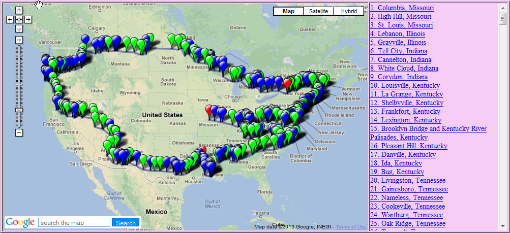
Click on Thumbnail for MapYou get four for the price of one in this post, as long as you're willing to let me ramble a little bit on my love for maps of all kinds.  You can't get everything for free!  Click on the thumbnail of the map at right to see the physical representation of all the reflections we are getting from William Least Heat-Moon's (LHM) trip around the U.S.

Book Quote

"U.S. 171 was traffic, fumes, heat, grim faces.  I became a grim face and drove.  Rosepine, Anacoco, Hornbeck, and Zwolle - alphabetically, the last town in the Rand-McNally Road Atlas (Abbeville, just south, is the first)."

Blue Highways: Chapter 3, Part 14


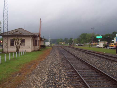
Clouds gather over Zwolle, Louisiana. From Bill Johnson's Steam Trip Journal. Click on photo to go to host site.

Rosepine, Anacoco, Hornbeck and Zwolle, Louisiana

Since we're hitting a number of Louisiana places in LHM's Blue Highways in this post, and since I know nothing about these places, and since he mentions the Rand-McNally Road Atlas, I am going to write about my lifelong love of maps.  I guess you would have never thought that I love maps, since this site is at least 50 percent about maps, but yes, it is true, I do.

I'm not sure where I got this fascination with maps, but I know that if I look at a map of, let's say Louisiana, and see a name like Anacoco or Zwolle I really start to wonder about that place.  Why is the name so different or interesting?  That might make me look something up to find out more about the place.  So, for example, I look up Zwolle and find out that it was named after the Dutch hometown of a rich coffee merchant who gave money to help the completion of a railroad between Port Arthur, Texas and Kansas City.  Unfortunately, I can't find anything on Anacoco...yet.

But just answering, or attempting to answer, those questions and looking at Zwolle's and Anacoco's locations on the map really does something for me.  Once I've looked into them, I start wondering what is around them that's interesting.  What does the map tell me?  Both are very near the Toledo Bend Reservoir, which sits astride the border of Louisiana and Texas.  I wonder about the natural scenery along the reservoir, especially since the Sabine National Forest nestles along the reservoir on the Texas side.   The name "Sabine" is interesting.  Does it refer to the mythological Rape of the Sabine Women, who in Roman legend were taken forcibly by early Romans looking for wives in the neighboring town? What does the country look like?  Knowing a little bit about that part of Texas, I assume that it's flat.  But, I've also traveled enough to know that looks can be deceiving.  In New Mexico, where I now live, up north near Taos is high, relatively flat desert between mountain ranges.  But in the middle of that desert, sneaking up on you before you even know it, is the magnificent Rio Grande Gorge with the fifth highest bridge in the United States spanning it.  Here, imagination can't even begin to describe the reality.

When I was in junior high school, about seventh and eighth grade, I was very much into science fiction and fantasy, and like many of those authors I could imagine whole worlds in my head.  Some of that fantasy coming out involved making maps of my own.  I built my own kind of Risk games with lands that I created.  Sometimes they were modeled on the four acres that I grew up on, or the thirteen acres of property we owned along a river.  Our driveway became a river, and I set up old parts of mechanical things I found in the barn to be the rudiments of capital cities or factories.  I imagined kingdoms either in the far past or in a post-apocalyptic future, even before I knew what post-apocalyptic meant.  I kept them in my head, but occasionally, to give them life, I would draw a map and flesh out those aspects of the countries and cities I had created, giving them new life.

To me, like a book, a map tells stories.  It doesn't necessarily matter whether the stories are true or not.  The map is a representation of physical features, but as a representation it can be populated with whatever I desire.  It may guide how I look at the world, but it cannot truly represent everything in the world, especially those things I don't have direct experience with.  In fact, sometimes, actually visiting a place can take the fun and wonder out of imagining it on a map.  When the world wasn't just a mouseclick away, a map fuzzily defined the borders between the real and the fantastical.  Look at how many maps were drawn in eras past by cartographers who, only based on what they heard or imagined, blurred the lines between what was real and what wasn't!  "Here be dragons!"  Ultima ThulePrester John's mythic kingdom in the Far East.  Atlantis.  The fact that none of these were truly known to exist in those times didn't stop the cartographers from imagining them and representing them on a map based on speculation and hearsay.

To this day, and I'm 47 years old, if I come upon a map I will often stop and study it in detail.  Maps capture and captivate me, much as a good book will lure me in, except that with a map, I use the map's represented space to fill in my own fantasies about the real place.  Sometimes, my musings are better than the reality, but sometimes the reality represented on the map puts my fantasies to shame.  That's the beauty, and the mystery, of the map.

If you want to know more about Rosepine, Anacoco, Hornbeck and Zwolle

Leesville Daily Leader (newspaper serving Rosepine, Anacoco and Hornbeck)
The Sabine Index (countywide newspaper serving Zwolle)
Town of Hornbeck
Town of Zwolle
Wikipedia: Anacoco
Wikipedia: Hornbeck
Wikipedia: Rosepine
Wikipedia: Zwolle

Next up: Shreveport, Louisiana

Monday
Jan102011

Blue Highways: Lake Charles, Louisiana

Unfolding the Map

Click on Thumbnail for MapUp over the bridge, the lake curving under us with smoky refineries and a gleaming casino at the water's edge.  We'll pass right by Lake Charles, and head north with William Least Heat-Moon toward Shreveport.  Click on the map thumbnail to see where we are located now.

Book Quote

"At Lake Charles, another sinuous parabola of bridgeway, an aerial thing curving about so I could see its underside as I went up.

"The city stretched below in a swelter of petrochemical plants and wharves. I got through only with effort and pressed north to state 27."

Blue Highways: Chapter 3, Part 14

Lake Charles, Louisiana. Photo hosted at Derenda.com. Click on photo to go to host site.

Lake Charles, Louisiana

Lake Charles was always a little bit of a mystery to me when I passed by it a couple of times on the way to and from New Orleans from Texas.  The freeway, I-10, would suddenly rise on a bridge over the lake.  On the shore to the south, petrochemical plants smoked away and there, in the midst of the plants was a large casino.

It seemed to me to encapsulate the major addictions of the American psyche.  One addiction, our constant need for petroleum and petroleum-based products, is pretty apparent.  Where would America be economically if we didn't use the 25% of the world's oil that we use?  (That percentage puts U.S. use first among all nations by a wide margin.  The country next on the usage list, China, uses only nine percent of the world's oil.)  Most of our usage goes to automobiles, so our oil addiction feeds our addiction to auto travel.  I'm not saying this is bad - I certainly wouldn't be where I am today without access to a vehicle.  However, I'm saying that one day the gravy train will end as oil is such a finite resource, and coming off of our addictions will be a hard withdrawal.

Our addiction to oil makes it possible for Americans to travel to places like Lake Charles, or Gulf Coast Mississippi, or to various Indian reservations, to feed another addiction, gambling.  It makes it possible even for us to visit the grandaddy of all places devoted to cashing in on addictions, Las Vegas.  As a country, we love to gamble!  In 2004, it was estimated that 54.1 million Americans visited casinos (http://www.overcominggambling.com/facts.html).  Of course, the recent economic troubles in the United States have cut deeply into our ability to both travel, because fuel costs more and even addicts will cut back a little on their habit if money is tight.  The casinos, and really, everything associated with leisure and entertainment, has been hit very hard in the recession.  So, I can't imagine that times are really good in places like Lake Charles right now.  Places that depend on these industries will do well when the times are good, but really take a hit when times are tough.

I didn't ever stop in Lake Charles, but know a person who grew up there.  She is the wife of a graduate school colleague of mine, and they would make many trips from New Orleans to Lake Charles to visit her family.  They now live in Houston, a little closer to Lake Charles, and I'm assuming they get to see family a little more often now.

Nellie Lutcher, a pioneer R&B and jazz pianist who was well known especially in Los Angeles where she often played in joints on Central Avenue, recorded a song about her hometown.  The song is called the Lake Charles Boogie.  I give it to you here, from YouTube, for your listening pleasure.  It's not every place that can inspire some fine rhythm and blues!

If you want to know more about Lake Charles

City of Lake Charles
Lake Charles American Press (newspaper)
Lake Charles Convention and Visitors Bureau
Wikipedia: Lake Charles

Next up: Rosepine, Anacoco, Hornbeck and Zwolle, Louisiana

Monday
Jan032011

Blue Highways: Kaplan, Louisiana

Unfolding the Map

Click on Thumbnail for MapThe land is flat.  Very flat.  It's humid and there's lots of rice grown here.  We are in Kaplan, Louisiana, passing through with William Least Heat-Moon (LHM) as he drives around America.  Click on the thumbnail at right to see where Kaplan is located, and bring out your bug spray - there's mosquitos.

Book Quote

"The rice fields began near Kaplan, where the land is less than twenty feet above the sea only thirty miles south, and kept going all the way to Texas."

Blue Highways: Part 3, Chapter 14


Rice dryers in Kaplan, Louisiana. Photo by Alysha Jordan on Flickr. Click on photo to go to host site.

Kaplan, Louisiana

Since not much comes to my mind from reading the quote, let's see where we go with it.  I haven't been in this part of Louisiana, and I don't know much about rice.  I know that there isn't much difference in the landscape between New Orleans and Houston along the Louisiana coast - bayous and swamps.  It's all part of an immense river basin drainage system.

In times past, before the Army Corps of Engineers put flood control features in place to control the route of the Mississippi River, the Mississippi was like a snake lashing its tail.  The mouth of the Mississippi has been in various places over the millennia - near Houston, through the Atchafalaya Basin, presently past New Orleans and down to its mouth at Bird's Foot Delta (or Balize Delta, as some call it).

The river has changed course for a variety of reasons.  Along the upper parts of the Mississippi, course changes have occured because of geological obstructions and seismic activity.  In 1811-12, the earthquakes along the New Madrid Fault temporarily reversed the flow of the river, carved new lakes and left communities once on the river high and dry when the earthquake moved the course of the river farther to the west or to the east.  The mouth has changed it's location too, primarily due to sedimentation.  The silt carried by the river gets deposited near the mouth, raising the level of the mouth and causing river to thrash west or east to find a more direct way to the Gulf.  This happens every thousand years or so.  Currently, it seems to want to shift west.  LHM makes reference to this in Blue Highways, when he quotes a Cajun named Cassie Hebert:

"The Atchafalaya's a shorter way to the Gulf than the Mississippi take.  Big river gonna find us down here.  Corps be damned.  One day rain gonna start and keep on like it do sometimes.  When the rainin' stop, the Mississippi gonna be ninety miles west of N'Orleans and St. Martinville gonna be a seaport.  And it won't be the firstest time the river go running from Lady N'Orleans."

What this has done has created fine land for growing rice.  Rice needs wet, wet land to grow, and a belt extending from roughly Lafayette, Louisiana to Corpus Christi in Texas is known for long and medium grain rice, and specialty rices.

My only experience in country similar, perhaps, to the area where Kaplan is located has been in Bangladesh.  That whole country is really a river delta and river mouth.  On the west, the Ganges flows into Bangladesh, becoming the Padma.  It combines with the Jamuna River and takes the name Padma, which then joins the Meghna and takes the Meghna's name, finally emptying into the sea.  In this delta land, uncontrolled by humans, floods are yearly and spectacular.  The country literally fills up during the monsoon season, leaving only high bits of land and roadways above water.  After monsoon season, the waters subside, and rice and other plants grown in paddies and very wet soil thrive.  One is literally at the mercy of the elements, and at the mercy of all the insects that thrive in wet climates, and the deadly diseases that they bring.

I don't know if I'll ever get to Kaplan, but I imagine it to be flat, hot in summer, and very steamy.  It's climate is probably much like New Orleans and Houston.  Kaplan calls itself the "Gateway to Acadiana," and it is the childhood home of country music star Sammy Kershaw.  It has an interesting past - even though it is the gateway to Cajun country, its founder was a Jewish rice entrepreneur named Abrom Kaplan.  Passing through here will bring you into the Cajun country we've visited with LHM previously.  In ensuing years, Kaplan may be tested by possible human-caused events like climate change - should sea levels rise, Kaplan may become ocean-front property, or be underwater.  Or, should droughts become more common, rice growing may become more difficult.  But until those events become reality, Kaplan can still serve as the entrance, or in our case exit, to Cajun music and culture.

If you want to know more about Kaplan

Institute of Southern Jewish Life: Profile of Kaplan
Kaplan, Louisiana - Gateway to Acadiana
Real Cajun Recipes (Cajun recipe site compiled by three Kaplan natives)
Wikipedia: Kaplan

Next up: Lake Charles, Louisiana

Saturday
Jan012011

Blue Highways: Abbeville, Louisiana

Unfolding the Map

Click on Thumbnail for MapHappy New Year!!!  In this January 1, 2011 post, we stop for some oysters in Abbeville with William Least Heat-Moon (LHM), and reflect on whether disasters, human- and nature-made, will lead to the end of the oyster industry in Acadiana and take with them a unique culture and cuisine.  Read on, and taste these morsels with us!  And click on the thumbnail at right to see where on the map, and where in our journey, Abbeville is located.

Book Quote

"My last chance at Cajun food was Abbeville, a town with two squares: one for the church, one for the courthouse. On the walk at Black's Oyster Bar a chalked sign: FRESH TOPLESS SALTY OYSTERS. Inside, next to a stuffed baby alligator, hung an autographed photo of Paul Newman, who had brought the cast of The Drowning Pool to Black's while filming near Lafayette. Considering that a recommendation, I ordered a dozen topless ("on the halfshell") and a fried oyster loaf (oysters and hot pepper garnish heaped between slices of French bread). Good enough to require a shrimp loaf for the road."

Blue Highways: Part 3, Chapter 14


Black's Oyster Bar in Abbeville, Louisiana. William Least Heat-Moon ate here on his way through town. Photo at nssf04's photostream at Flickr. Click on photo to go to host site.

Abbeville, Louisiana

One last Cajun meal, one last batch of oysters.  When LHM went through Abbeville and stopped at Black's Oyster Bar, I’m sure the thought never crossed his mind that oysters, which seemed so plentiful along with crawfish and shrimp, would quite possibly become a commodity that would be one day difficult to find.

Elsewhere in this blog I opined about how I love oysters.  I wrote about getting them on the half shell.  I may have mentioned that one of the best things to do is make your own oyster sauce – a little horseradish combined with some Tabasco or Louisiana Hot Sauce and you have yourself a bit of a kick to put on them.  Then, you put the shell to your lips, tip your head back, and let them slide with the hot sauce right on down.  Whether you chew them, or just let them go down your throat alive, they’re all good.

I may have also written that two fried delicacies that practically made me see God involved oysters.  The garlic-oyster po-boy, served in some fine New Orleans establishments but made particularly well by Liuzza’s by the Track just off Esplanade Avenue, is so good that I could literally eat one every day.  I’d weigh 300 pounds by now if I did, but they are that tasty that I wouldn’t care.  I could be having a coronary because of arterial sclerosis caused by too many garlic oyster po-boys, and if I were clutching my heart with a bit of one in my mouth, I’d consider it my honor to have died that way.

But the best, most wonderful oyster dish I had was something that even I had trouble envisioning until I tasted it.  Fried oysters wrapped in bacon.  Yes, it’s true.  Fried oysters taste like heaven, and then wrap some bacon around them, (because everything tastes better with bacon, right?) and you have a heavenly treat that’s a major sin to eat.  After eating one of those get out your rosary, because you need to do penance right there…and consign yourself to hell if you eat a whole meal of them.  I saw the light and never looked back after that meal.

I don’t revisit these things just to remember.  I revisit them because frankly, with hurricanes and with large oil spills, I fear for the fishing industry on the Louisiana coast.  Oyster beds that have been harvested for decades were put in danger by these events.  Shrimping businesses passed down through generations are in trouble.  These are major economic engines for Louisiana, particularly Cajuns, and a major reason that tourists go to New Orleans and the rest of Louisiana.  They are in mortal danger.  I want to go back and have my shrimp gumbo and my oyster po-boys.  I want future generations to be able to experience these delights.  LHM says that somewhere in Louisiana there has to be a bad chef but he never found one.  I know that from living in Louisiana, you have to go out of your way to find bad food there.  I know that there will be adaptation and renewal, and yet I worry about a culture, a cuisine and a way of life that could be gone within a generation.

I will be back in New Orleans in March.  I will stay with good friends and find good food – the best things that Louisiana has to offer.  And I will hope that these wonderful aspects of Louisiana that are unique to the United States, that make our rapidly homogenizing country a little more interesting, will be around for a while, and hopefully for a long time.  "Laissez les bontemps roulet," goes the French saying – let the good times roll.  I’m planning to take as much advantage of these cultural gems for as long as I can, and will by eating gumbo and oysters, dance to some Cajun music, and wash it all down with an Abita Amber or a cold Dixie.  Laissez le bontemps roulet, and let them live long!

If you want to know more about Abbeville

Abbeville's "5000 egg" giant omelette celebration
Black's Oyster Bar review
City of Abbeville
VermilionToday (newspaper)
Wikipedia: Abbeville

Next up:  Kaplan, Louisiana

Friday
Dec242010

Littourati News: Merry Christmas and Happy Holidays!

On this Christmas Eve as I write this, I hope that all of you travelers and Littourati out there have a wonderful holiday season.  Whether your travel is in the real physical world, or you are traveling through your thoughts and reflections as you partake in a piece of literature, I wish for continued happy journeys for you all.

Since this blog is presently with William Least Heat-Moon and Blue Highways in Louisiana Cajun country, I am embedding the video, below, of The Real Cajun Night Before Christmas.  Enjoy!


Best wishes for a Merry Christmas, happy holidays, and a wonderful, wonderful New Year!


Michael L. Hess