Current Littourati Map

Neil Gaiman's
American Gods

Click on Image for Current Map

Littourari Cartography
  • On the Road
    On the Road
    by Jack Kerouac
  • Blue Highways: A Journey into America
    Blue Highways: A Journey into America
    by William Least Heat-Moon

Search Littourati
Enjoy Littourati? Recommend it!


Littourati is powered by
Powered by Squarespace


Get a hit of these blue crystal bath salts, created by Albuquerque's Great Face and Body, based on the smash TV series Breaking Bad.  Or learn about other Bathing Bad products.  You'll feel so dirty while you get so clean.  Guaranteed to help you get high...on life.

Go here to get Bathing Bad bath products!

Entries in William Trogdon (145)

Tuesday
Mar152011

Blue Highways: Playas, New Mexico

Unfolding the Map

Click on Thumbnail for MapA town is transformed, in the emptiness of New Mexico, from a collection of trailers when William Least Heat-Moon (LHM) drove through thirty years ago to a bustling company town to an abandoned set of buildings used for a training center focusing on terrorism.  Thirty years is a long time, and a blink of an eye.  Click on the map to see where this interesting New Mexico location is situated.

Book Quote

"For the fourth time that day, I crossed the Continental Divide, which at this point, was merely a crumpling of hills.  The highway held so true that the mountains ahead seemed to come to me.  Along the road were small glaring and dusty towns: Playas, a gathering of trailers and a one-room massage parlor ($3.00 for thirty-five minutes the sign said)...."

Blue Highways: Part 4, Chapter 12

This is what your likely to see in Playas, New Mexico (also known as Terror Town) these days. Photo at the InfraNet Lab blog. Click on photo to go to host page.

Playas, New Mexico

How things can change in thirty years.  When LHM traveled through Playas thirty years ago, it was, as he describes above, "a gathering of trailers" and a massage parlor.  Playas was located in a state, New Mexico, that is the fifth largest in terms of area in the nation, and the sixth smallest in terms of population density at 17 persons per square mile.  Only South Dakota, North Dakota, Montana, Wyoming, and Alaska have less people per square mile than New Mexico.  Of the two million people that live in New Mexico, over half of them live in the Albuquerque and Santa Fe metro areas.  In other words, there is a whole lot of empty space in New Mexico.

In my frequent drives from Albuquerque to Lubbock in 2008-2009, I traveled through a lot of those empty spaces.  Because business and commerce tends to cluster around freeways, one doesn't get a sense of just how empty New Mexico can be until one ventures off onto the blue highways that LHM writes of.  Between Santa Rosa and Fort Sumner, I got a sense of just how empty New Mexico is.  Also, if one, rather than driving northwest from Fort Sumner to the freeway, continues driving west, the emptiness is sublimely beautiful.  Arid grasslands, with hardly a tree to be seen - just some scrub bushes here and there along with the lonely sound of a railroad horn.

Because of its relative emptiness, New Mexico is bursting with military and law enforcement training activity.  Near Socorro, where New Mexico Tech's campus is located, the air force practices bombing runs with low flying planes.  White Sands Missile Range, besides being the place where the first atomic bomb was tested, has been used to test rockets and missiles for military and peacetime activities.  It is in some of these empty spaces, down by Truth or Consequences, that New Mexico has begun building an international spaceport which will be anchored by the activities of Virgin Galactic.  In the next few years, the company plans to take tourists to the edge of space in a rocket-powered plane that will then glide back to earth after the space tourists experience about ten minutes of zero gravity.

One can find throughout New Mexico these lonely places.  Where there are towns, they look like they are just barely hanging on to the edge of the world.  I imagine that Playas was like that - a set of trailers that looked like they might be carried off by the next gust of wind, leaving nothing but a dirt devil their wake.

Today, however, Playas as a town is no more.  According to its entry on Wikipedia, the town was begun as a company town for a copper smelter.  All residents of the town were evicted in 1999 when the Phelps Dodge Company closed the plant.  By then, the town had grown to include 250 homes, some apartments, a bar, bowling alley, a rodeo ring, and a fitness center.  The town lay dormant, a skeleton crew its only inhabitants, until New Mexico Tech University purchased it in 2003.  It is now used for training for counter-terrorism efforts, first responders, and for awhile, US military assisting Border Patrol agents.  That last fact is a supreme irony, since the lights of the smelter has evidently been nicknamed by illegal immigrants crossing the border as La Estrella del Norte, or The Star of the the North.

Even as people take control of aspects of their lives through technology and commerce, some things, like time and market forces, are beyond control and may cause the birth and death of settlements, towns, villages, and even cities.  We reach out to the stars, using man-made stars to guide our way north across borders in hopes of a new life, or using rocket fuel to take us to the brink of the void, and yet even as these activities are ongoing, towns are evicted, wars cause deaths, and natural earth movements fling towering waves of destruction against our strongly built, seemingly impervious structures.

But still we sit in the emptiness, look about us, and continue to work with what is while dreaming of what will be.

Musical Interlude

For today's musical interlude, since I wrote about stars, I go back to Terri Hendrix of Texas, and offer you her song Lluvia de Estrellas, which literally means "rain of stars" and is really a very poetic description of a meteor shower.  Enjoy!


If you want to know more about Playas

Albuquerque Journal: N.M. Tech Buys Playas for Terror Training Center
Center for Land Use Interpretation: Playas
Washington Post: New Mexico Plays Home to Terror Town
Wikipedia: Playas

Next up: Animas, New Mexico

Sunday
Mar132011

Blue Highways: Hachita, New Mexico

Unfolding the Map

Click on Thumbnail for MapIn dry, dusty, remote Hachita, only about ten miles from the Mexican border, we stop for a moment at the Desert Den and ponder old and new and whether we can hope that we will remain a connected people in the face of the wonders and terrors of technology.  Whew!  That's a lot of pondering!  Click on the thumbnail at right to see where Hachita fits on our map.

Book Quote

"Off to the south lay the Big Hatchet Mountains, their backs against the deserts of Mexico; under them, tiny Hachita sat almost squarely on the Continental Divide where it bends east and west....

"Hachita, facing an abandoned railroad trackbed and locomotive water tower, turned out to be a conglomerate of clay bricks and wood and aluminum.  In sandy lots between faded trailers and adobe houses, old cars mummified in the dry air.  There were two businesses: a small grocery and the Desert Den Bar & Filling Station."

Blue Highways: Part 4, Chapter 11


Abandoned home in Hachita. Photo by lad78518 on Flickr. Click on photo to go to site.Hachita, New Mexico

In a world where we can communicate in a blink of an eye with hand-held devices, a place like Hachita seems almost out of place.  Even at the time the LHM traveled through Hachita, this remote place was accessible by telephone - now it is presumably accessible by satellite TV and wi-fi internet.  Yet I doubt that Hachita is much different today than it was 30 years ago.  If the Desert Den Bar & Filling Station is still in existence, it probably looks much the same as it did.  You get the sense from LHM that Hachita is dying, on its way to becoming a ghost town like the ones I wrote about some ways back along our path.

But only a few hours away from Hachita is a place where, in a bright flash, technology took a great leap forward for better and worse.  A few paragraphs down in this Blue Highways chapter, a patron of the Desert Den tells his story about seeing the first explosion of an atomic bomb in the New Mexico desert:

"Curled up against a big rock out of the wind.  I was still in my bedroll at daybreak when come a god-terrible flash.  I jumped up figurin' one of the boys took a flashbulb pitcher of me sleepin' on the job.  Course nobody had a Kodak.  Couple minutes later the ground started rumblin'.  We heard plenty of TNT goin' off to Almagordy before, but we never heard nothin' like that noise.  Sound just kept roarin'.  'Oh, Jesus,' I says, 'what'd they go and do now?'  Next month we saw wheres they bombed Heerosaykee, Japan.  We never knowed what n A-tomic bomb was, but we knowed that one flash wasn't no TNT blockbuster."

Blue Highways: Part 4, Chapter 11

A large part of New Mexico's economy is based on research that culminated in the blast in the New Mexico desert.  Los Alamos, New Mexico, like Oak Ridge, Tennessee was one of America's secret cities devoted to atomic research.  Once the blast happened, it was almost as if Pandora's Box had been opened.  Secrets of atomic research morphed into advances in both military and peacetime technology.  Unlocking secrets of the atom made exploration into the world of the very small yield huge results, whether those results were megaton explosions or an explosion in communications, medical, construction, engineering, and computing technologies.

And yet...

Despite the exciting things that go on in the big cities, despite the bells and whistles of our civilization, some aspects of our human existence still remain constant.  In Hachita, it is a bar called the Desert Den (at least during LHM's trip through), and this is replicated everywhere throughout America.  What do we really need?  At the end of the day, if we forget all the gadgets and the modern conveniences, we need a place to gather, to communicate, to eat and drink and play games and simply be together.  Today, we try to put a hi-tech veneer over it all.  We socialize on Facebook, we share news through Twitter (in 140 character bites), and we gather more information from the World Wide Web.  We use our cell phones and text each other.  We buy our goods electronically from online stores and EBay.  But what are all these actions nothing but maintaining our connections with each other?  What are we doing except coming together to engage with each other?  The electronic communication medium is simply a high tech Desert Den.  In many ways, this for the good.

And yet...

The lack of face-to-face contact is a troubling aspect of this technological revolution.  People text and e-mail things they would never say to each other face to face.  The ability to choose how we present ourselves, always present in the "real" world but now available with all the enhancements of the technological world, has researchers discussing how our electronic gadgets fuel personality disorders, such as narcissism, that might be more controlled in face-to-face social situations.  Take all of this communication-by-proxy back to the 1940s, and we can see how dropping an atomic bomb built in secret cities around the US, then assembled and tested in a New Mexico desert region named by the Spanish Jornada del Muerto (Journey of the Dead), contributed to and enhanced an age of disconnected warfare.  Back then, the Enola Gay dropped its payload and then made a quick turn.  The pilots never had to see the devastation and death their bomb caused.  Today, Predator drones operated by technicians in faraway bunkers fire missiles at suspected terrorist gatherings.  We are at risk of a paradox - as we become more connected electronically, we become more disconnected as humans in reality.

Hachita, and small communities, should serve as a reminder of a time when a small town functioned as our Facebook, Twitter, Internet, marketplace and every other type of gathering place imaginable.  No matter how small, the local watering hole was the place to come when we were lonely and needed company on a daily basis, and some people even made regular trips of a day or more, if they lived quite remotely, to have a few hours of human contact.  I love progress, but I am concerned that progress might offer a flashy way to meet our emotional needs but ultimately separate us from what we really need - real, physical interpersonal connection.  We only need to remember a mushroom cloud rising over a desert floor and over a couple of cities in Asia to know that once we disconnect from each other, terrible things can happen.

When Pandora's Box was opened, all evil escaped into the world, yet down at the bottom of the box was Hope.  I hope that our advances, that do so much good and so much evil, do not take away our greatest assets and creativities born out of our desires to be together.

Musical Interlude

The Pilgrim Travelers, a gospel R& B group that included a young Lou Rawls, sang Jesus Hits Like an Atom Bomb.  I thought given that New Mexico was the first test site of the atom bomb, the song was appropriate for this post's interlude.

If you want to know more about Hachita

ghosttowngallery.com: Old Hachita, New Mexico

You won't find much else about Hachita unless you visit there.  However, I would encourage you, if you are in New Mexico on the first Saturday of either April or October, to visit the Trinity Site on the White Sands Missile Range.  This is where the first atomic bomb was exploded, and a rock obelisk marks the site.

Next up: Playas, New Mexico

Friday
Mar112011

Blue Highways: Deming, New Mexico


Unfolding the Map

Click on Thumbnail for MapWe cross another border into New Mexico with William Least Heat-Moon (LHM) and discover why New Mexico chile is a force to be reckoned with.  Let's stop a moment and savor the delicious heat.  Click on the thumbnail of the map at right to see where Deming, the town that where we pass some time, is located.

Book Quote

"She served a stack of unheated flour tortillas, butter and a bowl of green, watery fire that would have put a light in the eyes of Quetzalcoatl.  Texans can talk, but nowhere is there an American chile hot sauce, green or red, like the New Mexican versions, with no two recipes the same except for the pyrotechnical display they blow off under the nose.  New Mexican salsas are mouth-watering, eye-watering, nose-watering; they clean the pipes, ducts, tracts, tubes; and like spider venom, they can turn innards to liquid."

Blue Highways: Part 4, Chapter 10

Downtown Deming, New Mexico. Photo by Kristine and at her blog Adventures in Life. Click on photo to go to host page.

Deming, New Mexico

Every year, in Albuquerque where I live, there is a National Fiery Foods Show.  In a large casino convention hall, the room is packed with booths where vendors show off their latest chile sauces, barbecue sauces, salsas, chile powders, and other hot and spicy confections.  Did you know that there is chile ice cream?  How about chile-spiced chocolates, or even better, chile spiced chocolates wrapped around bacon.  The newest technologies and techniques for harvesting chile is on display, and at the last one, I got to sample the latest of the hottest chiles ever grown, the bhut jolokia chile cultivated in India.  I had a sample of a sauce made with a little of that chile, and it was extremely mouth burning.  One goes to the Fiery Foods Show with an iron stomach and, if one needs it, a lot of antacid.

In southern New Mexico, chile is king.  The area around Hatch, New Mexico is prime chile growing country, but even backyard gardners around the state try their hands at making their own chiles.  One thing I love about New Mexico is the fall, when suddenly the air is filled with the smell of roasting green chile.  At our local farmers market, we can often buy fresh chile from an organic farmer, take it over to a guy with a portable chile roaster, and have it roasted right there in front of us in about 10 minutes.

If given a choice, I usually prefer green chile over red.  They are really the same plant - the red chile is really green chile left on the vine a little longer.  But I like the taste of a good medium to hot green chile.  You can still taste the flavor with the hotness built in.  My wife likes mild to medium green chile.  At a local restaurant in Albuquerque, the Frontier, she will often order her meal with chopped green chile on the side so that she can mix in the spiciness to her own comfort.  However, I love a good carne adovada, which is shredded or diced pork slow cooked in a red chile sauce.  I also love posole - a really good posole can make you weep in happiness - which is hominy and beef or pork in a red chile broth.

New Mexico chile is important to the state.  It is one of the things that gives New Mexico its identity.  New Mexicans are very quick to take some umbrage if it is spelled wrong.  Often you see, in other states, the spelling of "chili."  Chili actually refers to a type of stew.  In New Mexico, it is always "chile."  Chiles are used for food and also for decoration.  Many houses hang ristras - tied-together bundles of red chile that serve as outside decorations, mostly on adobe houses to give them an extra air of authenticity.

I tried to grow chile once.  I put in a couple of small plants and got a couple of small chiles out of them.  I felt a little proud that I, too, was able to participate in something that is so much a part of this culture that I find myself living in, even if only in a small way.

I've never been to Deming, though I've been in the area, but I can imagine that what LHM describes in the restaurant he visited still holds true today.  One gets Tex-Mex in Texas, but one gets a unique, regional cuisine that is completely different in New Mexico.  And always, one is asked the ubiquitous question:  red or green with that?  Most people line up on one side or the other - a few like both.  Regardless, it's a cultural and gastronomic identifier that gives New Mexico a uniqueness as real as anywhere else.

Musical Interlude

In the spirit of food, the musical interlude for this post is by Boston group Sol y Canto, driven by the voice of Puerto Rican and Argentine singer Rosi Amador and the guitar of her husband, New Mexico's Brian Amador.  In any Latin culture, cuisine is king.  The song encourages us to forgo fast food and join the sumptuous feast of Latin home-cooking.  Salud, and enjoy!


If you want to know more about Deming

Bataan Death March Memorial
City of Deming
The Deming Headlight (newspaper)
Great American Duck Race
Wikipedia: Deming

Next up: Hachita, New Mexico

Wednesday
Mar022011

Blue Highways: El Paso, Texas

Unfolding the Map

Click on Thumbnail for MapWilliam Least Heat-Moon (LHM) doesn't want to stop in El Paso, but we will and take a look around.  While there, we'll see some murals, eat some Tex-Mex, view some art and listen to some music.  Where is El Paso on our journey?  Click on the thumbnail to your right to find out.

Book Quote

"El Paso was a pleasant city, but I felt I'd been in Texas for weeks, so I drove on west through the natural break in the Rockies that gives the town its name - the very pass Indians, conquistadors, and the Butterfield Stage used - drove around crumbling Comanche Peak, and headed up the Rio Grande."

Blue Highways: Part 4, Chapter 9


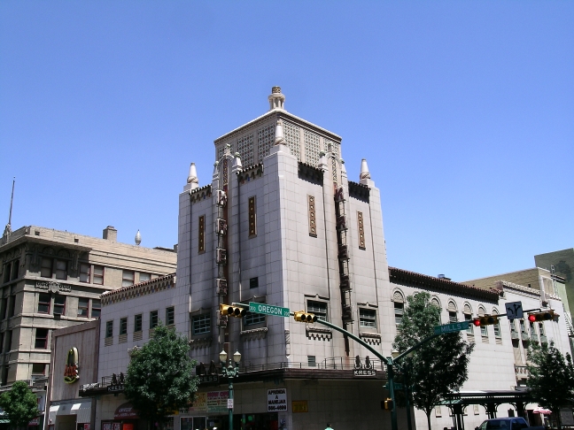
Kress Building in downtown El Paso. Photo by Michael L. Hess.

El Paso, Texas

LHM pretty much bypasses El Paso, which is unfortunate.  I know that larger cities aren't really what he's interested in, but El Paso is more interesting than you might think.  At the time that I write, El Paso is one of the safest cities in the United States.  This is pretty amazing, considering that just across the Rio Grande in Mexico, Ciudad Juarez had over 3000 murders in 2010.  In fact, El Paso is safe enough that the former mayor of Ciudad Juarez ran the city from El Paso, where he lived.  I guess being under death threats every day would make anyone want to stay away from one of the most dangerous cities in the world and be in one of the safest in the world, even if you are the former's top elected official.

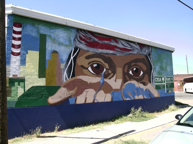
But El Paso seems to me to be pretty vibrant.  It is a city of murals, as I found when I visited there prior to a camping trip in the Guadalupe Mountains.  Everywhere around the city, local artists paint the issues that the community deals with - illegal immigration, HIV/AIDS - as well as the hopes of the residents.

El Paso Lacrimas mural. Photo by Michael L. HessLuis Jimenez, a nationally famous sculptor from El Paso who died while working on sculptures for the Denver Airport, has a piece in El Paso celebrating a couple of its more famous past residents - a pair of alligators that lived in a small zoo there.  They were an oddity in this western arid part of the country, and so the alligators were quite an attraction for the city, and now they are immortalized in fiberglass sculpture in El Paso's downtown.

Luis Jimenez' alligator sculpture in El Paso. Photo by Michael L. HessEl Paso also still maintains its very western feel, while at the same time being a vibrant crossroads of two cultures.  Walking the streets, one looks at the buildings and can imagine what the town looked like at the turn of the century when many of the buildings were erected.  Men in suits mingling with ladies in finery, but also cowboys just in from the dusty range, Indians selling their artistic creations, and Mexicans engaging in commerce and plying their trades.  One can just imagine the Marty Robbins song...

Out in the West Texas town of El Paso
I fell in love with a Mexican girl.
Night-time would find me in Rosa's cantina;
Music would play and Felina would whirl.

Blacker than night were the eyes of Felina,

Wicked and evil while casting a spell.
My love was deep for this Mexican maiden;
I was in love but in vain, I could tell.

Of course, some of the best Mexican food can be found there.  After living in San Antonio and enjoying our Tex-Mex, and then living in Albuquerque where the New Mexican food, smothered with red or green chile, is very different, we missed having good Tex-Mex food.  We were delighted to find it again in El Paso.

El Paso was also the catalyst for one of sports most defining moments, and a milestone for racial equality in the NCAA.  Legendary coach Don Haskins of Texas Western University, now the University of Texas at El Paso, fielded a basketball team of five African-American starters in the national championship game against a decidedly all-white Kentucky squad.  Texas Western's win in that game and its national championship is credited with helping desegregate college basketball squads all over the South.

I live three and one half hours away from El Paso now.  I would think twice about crossing the border into Ciudad Juarez, but I wouldn't hesitate visiting El Paso again.

Musical Interlude

The Marty Robbins tune is famous, but I thought I'd present you with a band that I actually saw and which you might not know about.  The Gourds, out of Austin, titled one of their songs El Paso.  It's got a nice beat.  Enjoy!

If you want to know more about El Paso

Chamizol National Memorial
El Chuco (Street photography of El Paso)
El Paso Convention and Visitors Bureau
El Paso Daily Photo (blog)
El Paso Times (newspaper)
Hueco Tanks State Park
Road Food America: H&H Cafe & Car Wash
Road Food America: Smitty's
University of Texas at El Paso
US Border Patrol Museum
Wikipedia: El Paso
World's Largest Man-Made Illuminated Star

Next up: Deming, New Mexico

Sunday
Feb272011

Littourati News: Blue Highways Stopovers Mapped in Google Earth in 2005

While doing some looking around on the web, I found that someone with the online name of "rvbooth" had mapped Blue Highways in 2005 on Google Earth.  It's a very nice job of mapping his route and includes polylines between the stopover points.

The difference between that earlier map and mine?  The earlier map shows only the stopovers that William Least Heat-Moon (LHM) made, whereas I am trying to map every point along his route that he mentions in the book, whether he stopped there or not.  Second, my map includes the relevant quotes from the book whereas the previous map does not.  Third, in keeping with my blog's stated purpose, I am including entries which are my own impressions, thoughts and recollections as I read LHM's words.  In a sense, it is like I am traveling with LHM, but keeping my own journal as I go.  In that way, I go a little more in depth into the book than the earlier map does.

I think it's a great resource - and will give you some idea of where we're going.  To see the map, you must have Google Earth or the Google Earth plug-in on your browser that will allow you to see Google Maps in Google Earth view. 

Go here to access rvbooth's kmz file

To compare with mine, go here to download my Google Earth kml file (in progress). 

Happy traveling!

Michael